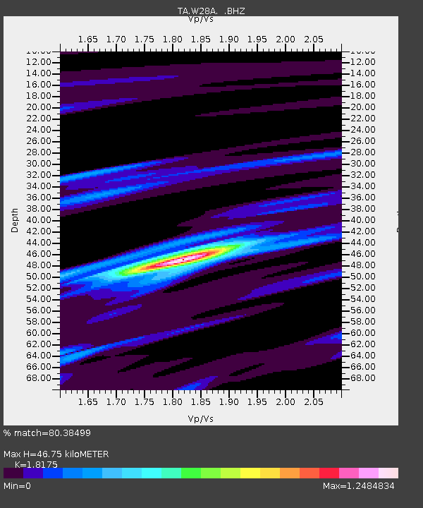
W28A Vega, TX, USA - Earthquake Result Viewer
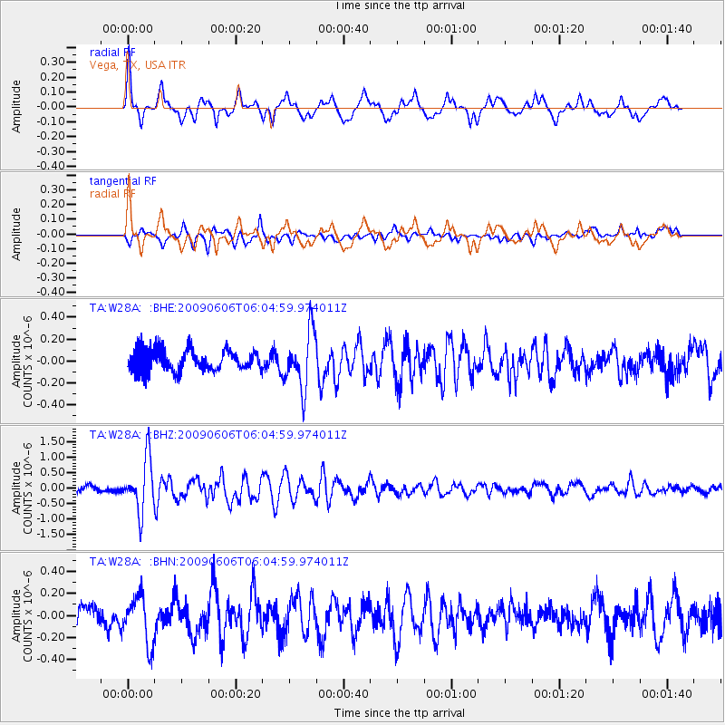
Earthquake location: Near East Coast Of Honshu, Japan
Earthquake latitude/longitude: 35.5/140.9
Earthquake time(UTC): 2009/06/06 (157) 05:52:43 GMT
Earthquake Depth: 34 km
Earthquake Magnitude: 5.8 MB, 5.4 MS, 5.8 MW, 5.7 MW
Earthquake Catalog/Contributor: WHDF/NEIC
Network: TA USArray Transportable Network (new EarthScope stations)
Station: W28A Vega, TX, USA
Lat/Lon: 35.26 N/102.21 W
Elevation: 1156 m
Distance: 88.3 deg
Az: 46.911 deg
Baz: 313.258 deg
Ray Param: 0.04266378
Estimated Moho Depth: 46.75 km
Estimated Crust Vp/Vs: 1.82
Assumed Crust Vp: 6.242 km/s
Estimated Crust Vs: 3.434 km/s
Estimated Crust Poisson's Ratio: 0.28
Radial Match: 80.38499 %
Radial Bump: 400
Transverse Match: 64.05678 %
Transverse Bump: 400
SOD ConfigId: 2648
Insert Time: 2010-03-05 23:06:16.075 +0000
GWidth: 2.5
Max Bumps: 400
Tol: 0.001

Signal To Noise

ChannelStoNSTALTA
TA:W28A: :BHZ:20090606T06:04:59.974011Z10.528318.568533E-78.138565E-8
TA:W28A: :BHN:20090606T06:04:59.974011Z2.2629832.1990603E-79.717529E-8
TA:W28A: :BHE:20090606T06:04:59.974011Z2.76772332.610282E-79.4311524E-8
Arrivals
Ps6.2 SECOND
PpPs21 SECOND
PsPs/PpSs27 SECOND