You are here: Home > Network List > TA - USArray Transportable Network (new EarthScope stations) Stations List
> Station W28A Vega, TX, USA > Earthquake Result Viewer
W28A Vega, TX, USA - Earthquake Result Viewer
| Earthquake location: |
Southern Peru |
| Earthquake latitude/longitude: |
-15.0/-70.4 |
| Earthquake time(UTC): |
2009/07/12 (193) 06:12:47 GMT |
| Earthquake Depth: |
199 km |
| Earthquake Magnitude: |
5.7 MB, 6.1 MW, 6.1 MW |
| Earthquake Catalog/Contributor: |
WHDF/NEIC |
|
| Network: |
TA USArray Transportable Network (new EarthScope stations) |
| Station: |
W28A Vega, TX, USA |
| Lat/Lon: |
35.26 N/102.21 W |
| Elevation: |
1156 m |
|
| Distance: |
58.4 deg |
| Az: |
329.614 deg |
| Baz: |
143.333 deg |
| Ray Param: |
0.062222403 |
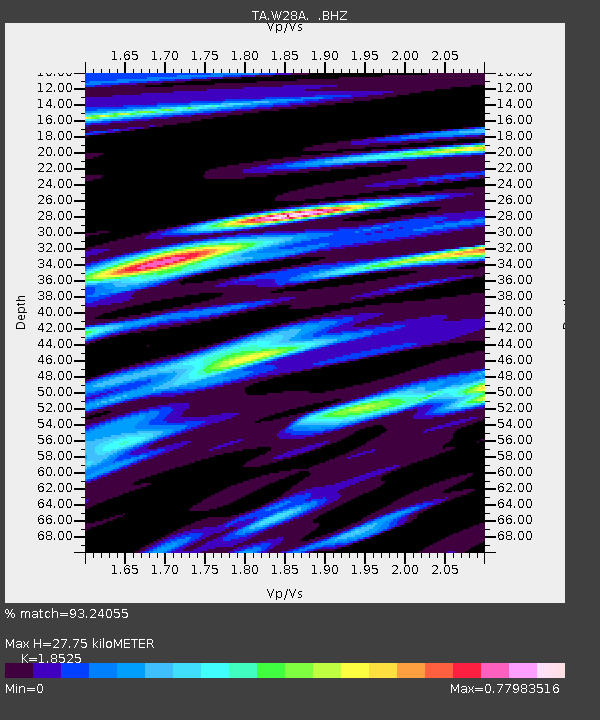
| Estimated Moho Depth: |
27.75 km |
| Estimated Crust Vp/Vs: |
1.85 |
| Assumed Crust Vp: |
6.242 km/s |
| Estimated Crust Vs: |
3.37 km/s |
| Estimated Crust Poisson's Ratio: |
0.29 |
|
| Radial Match: |
93.24055 % |
| Radial Bump: |
400 |
| Transverse Match: |
69.36561 % |
| Transverse Bump: |
400 |
| SOD ConfigId: |
2648 |
| Insert Time: |
2010-03-05 23:06:27.684 +0000 |
| GWidth: |
2.5 |
| Max Bumps: |
400 |
| Tol: |
0.001 |
|
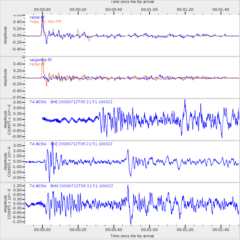
Signal To Noise
| Channel | StoN | STA | LTA |
| TA:W28A: :BHZ:20090712T06:21:51.10002Z | 21.711416 | 1.3563907E-6 | 6.247362E-8 |
| TA:W28A: :BHN:20090712T06:21:51.10002Z | 4.27232 | 4.0684318E-7 | 9.52277E-8 |
| TA:W28A: :BHE:20090712T06:21:51.10002Z | 4.6713605 | 3.0260207E-7 | 6.477814E-8 |
| Arrivals |
| Ps | 4.0 SECOND |
| PpPs | 12 SECOND |
| PsPs/PpSs | 16 SECOND |


