You are here: Home > Network List > TA - USArray Transportable Network (new EarthScope stations) Stations List
> Station W28A Vega, TX, USA > Earthquake Result Viewer
W28A Vega, TX, USA - Earthquake Result Viewer
| Earthquake location: |
Near Coast Of Northern Peru |
| Earthquake latitude/longitude: |
-6.6/-81.2 |
| Earthquake time(UTC): |
2009/02/09 (040) 14:09:02 GMT |
| Earthquake Depth: |
15 km |
| Earthquake Magnitude: |
5.5 MB, 5.5 MS, 6.0 MW, 5.9 MW |
| Earthquake Catalog/Contributor: |
WHDF/NEIC |
|
| Network: |
TA USArray Transportable Network (new EarthScope stations) |
| Station: |
W28A Vega, TX, USA |
| Lat/Lon: |
35.26 N/102.21 W |
| Elevation: |
1156 m |
|
| Distance: |
46.1 deg |
| Az: |
335.913 deg |
| Baz: |
150.299 deg |
| Ray Param: |
0.070846446 |
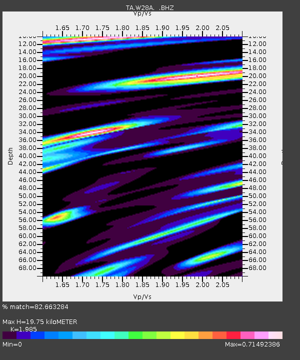
| Estimated Moho Depth: |
19.75 km |
| Estimated Crust Vp/Vs: |
1.99 |
| Assumed Crust Vp: |
6.242 km/s |
| Estimated Crust Vs: |
3.145 km/s |
| Estimated Crust Poisson's Ratio: |
0.33 |
|
| Radial Match: |
82.663284 % |
| Radial Bump: |
400 |
| Transverse Match: |
54.38201 % |
| Transverse Bump: |
400 |
| SOD ConfigId: |
2658 |
| Insert Time: |
2010-03-05 23:06:28.684 +0000 |
| GWidth: |
2.5 |
| Max Bumps: |
400 |
| Tol: |
0.001 |
|
Signal To Noise
| Channel | StoN | STA | LTA |
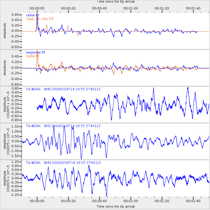
| TA:W28A: :BHZ:20090209T14:16:55.374012Z | 3.0552635 | 4.5760086E-7 | 1.4977459E-7 |
| TA:W28A: :BHN:20090209T14:16:55.374012Z | 1.6336393 | 3.2070741E-7 | 1.9631469E-7 |
| TA:W28A: :BHE:20090209T14:16:55.374012Z | 1.1751261 | 2.4849638E-7 | 2.114636E-7 |
| Arrivals |
| Ps | 3.3 SECOND |
| PpPs | 9.0 SECOND |
| PsPs/PpSs | 12 SECOND |


