You are here: Home > Network List > TA - USArray Transportable Network (new EarthScope stations) Stations List
> Station W28A Vega, TX, USA > Earthquake Result Viewer
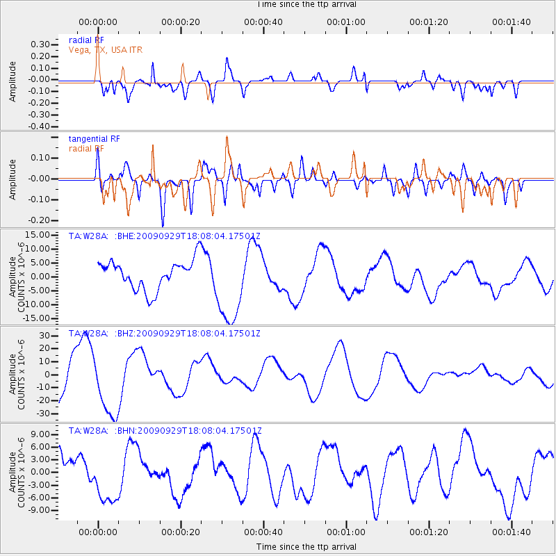
W28A Vega, TX, USA - Earthquake Result Viewer
*The percent match for this event was below the threshold and hence no stack was calculated.
| Earthquake location: |
Tonga Islands |
| Earthquake latitude/longitude: |
-15.4/-173.2 |
| Earthquake time(UTC): |
2009/09/29 (272) 17:56:05 GMT |
| Earthquake Depth: |
10 km |
| Earthquake Magnitude: |
6.0 MB |
| Earthquake Catalog/Contributor: |
WHDF/NEIC |
|
| Network: |
TA USArray Transportable Network (new EarthScope stations) |
| Station: |
W28A Vega, TX, USA |
| Lat/Lon: |
35.26 N/102.21 W |
| Elevation: |
1156 m |
|
| Distance: |
83.9 deg |
| Az: |
51.078 deg |
| Baz: |
246.512 deg |
| Ray Param: |
$rayparam |
*The percent match for this event was below the threshold and hence was not used in the summary stack. |
|
| Radial Match: |
65.27252 % |
| Radial Bump: |
400 |
| Transverse Match: |
59.853825 % |
| Transverse Bump: |
400 |
| SOD ConfigId: |
2622 |
| Insert Time: |
2010-03-05 23:06:45.792 +0000 |
| GWidth: |
2.5 |
| Max Bumps: |
400 |
| Tol: |
0.001 |
|
Signal To Noise
| Channel | StoN | STA | LTA |
| TA:W28A: :BHZ:20090929T18:08:04.17501Z | 1.5930183 | 2.441258E-5 | 1.5324733E-5 |
| TA:W28A: :BHN:20090929T18:08:04.17501Z | 1.4412012 | 6.2172317E-6 | 4.3139235E-6 |
| TA:W28A: :BHE:20090929T18:08:04.17501Z | 2.7847447 | 1.439997E-5 | 5.1710194E-6 |
| Arrivals |
| Ps | |
| PpPs | |
| PsPs/PpSs | |


