You are here: Home > Network List > CI - Caltech Regional Seismic Network Stations List
> Station MPM Manuel Prospect Mine, California, USA > Earthquake Result Viewer
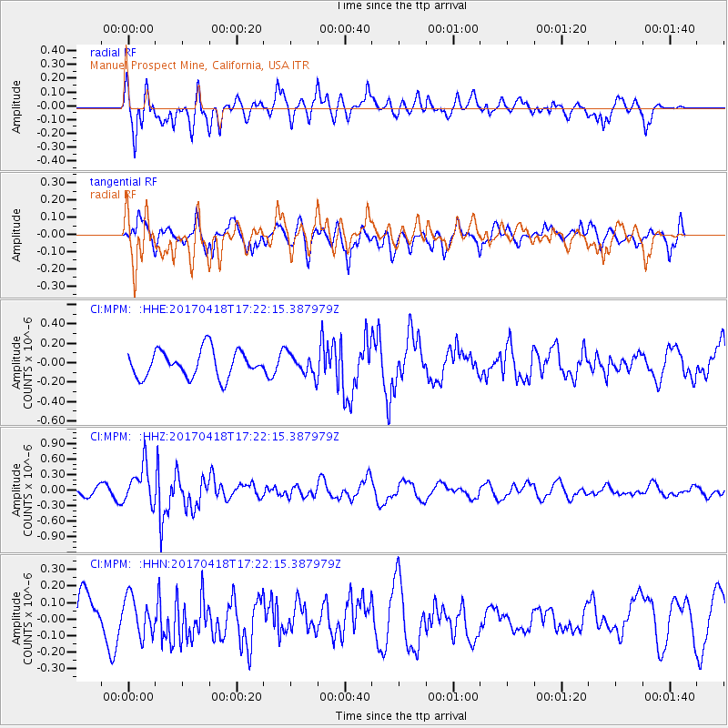
MPM Manuel Prospect Mine, California, USA - Earthquake Result Viewer
*The percent match for this event was below the threshold and hence no stack was calculated.
| Earthquake location: |
Fiji Islands Region |
| Earthquake latitude/longitude: |
-18.1/-178.4 |
| Earthquake time(UTC): |
2017/04/18 (108) 17:11:47 GMT |
| Earthquake Depth: |
626 km |
| Earthquake Magnitude: |
6.0 Mww |
| Earthquake Catalog/Contributor: |
NEIC PDE/us |
|
| Network: |
CI Caltech Regional Seismic Network |
| Station: |
MPM Manuel Prospect Mine, California, USA |
| Lat/Lon: |
36.06 N/117.49 W |
| Elevation: |
185 m |
|
| Distance: |
78.8 deg |
| Az: |
46.206 deg |
| Baz: |
237.943 deg |
| Ray Param: |
$rayparam |
*The percent match for this event was below the threshold and hence was not used in the summary stack. |
|
| Radial Match: |
64.78845 % |
| Radial Bump: |
400 |
| Transverse Match: |
66.55479 % |
| Transverse Bump: |
400 |
| SOD ConfigId: |
11737051 |
| Insert Time: |
2019-04-27 03:25:49.355 +0000 |
| GWidth: |
2.5 |
| Max Bumps: |
400 |
| Tol: |
0.001 |
|
Signal To Noise
| Channel | StoN | STA | LTA |
| CI:MPM: :HHZ:20170418T17:22:15.387979Z | 2.9894729 | 3.717852E-7 | 1.243648E-7 |
| CI:MPM: :HHN:20170418T17:22:15.387979Z | 0.859114 | 1.1563346E-7 | 1.3459618E-7 |
| CI:MPM: :HHE:20170418T17:22:15.387979Z | 0.79121673 | 1.0808778E-7 | 1.3660957E-7 |
| Arrivals |
| Ps | |
| PpPs | |
| PsPs/PpSs | |


