You are here: Home > Network List > US - United States National Seismic Network Stations List
> Station AMTX Amarillo, Texas, USA > Earthquake Result Viewer
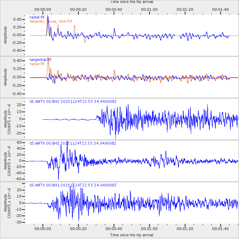
AMTX Amarillo, Texas, USA - Earthquake Result Viewer
*The percent match for this event was below the threshold and hence no stack was calculated.
| Earthquake location: |
Peru-Brazil Border Region |
| Earthquake latitude/longitude: |
-10.6/-71.0 |
| Earthquake time(UTC): |
2015/11/24 (328) 22:45:38 GMT |
| Earthquake Depth: |
602 km |
| Earthquake Magnitude: |
7.5 MWW, 6.9 MI |
| Earthquake Catalog/Contributor: |
NEIC PDE/NEIC COMCAT |
|
| Network: |
US United States National Seismic Network |
| Station: |
AMTX Amarillo, Texas, USA |
| Lat/Lon: |
34.53 N/101.41 W |
| Elevation: |
1010 m |
|
| Distance: |
53.4 deg |
| Az: |
328.577 deg |
| Baz: |
141.619 deg |
| Ray Param: |
$rayparam |
*The percent match for this event was below the threshold and hence was not used in the summary stack. |
|
| Radial Match: |
86.60653 % |
| Radial Bump: |
400 |
| Transverse Match: |
79.74965 % |
| Transverse Bump: |
400 |
| SOD ConfigId: |
1259291 |
| Insert Time: |
2015-12-08 23:43:26.361 +0000 |
| GWidth: |
2.5 |
| Max Bumps: |
400 |
| Tol: |
0.001 |
|
Signal To Noise
| Channel | StoN | STA | LTA |
| US:AMTX:00:BHZ:20151124T22:53:34.949008Z | 16.722963 | 7.795189E-6 | 4.6613684E-7 |
| US:AMTX:00:BH1:20151124T22:53:34.949008Z | 15.273969 | 2.7304864E-6 | 1.7876731E-7 |
| US:AMTX:00:BH2:20151124T22:53:34.949008Z | 5.1572127 | 2.005465E-6 | 3.8886606E-7 |
| Arrivals |
| Ps | |
| PpPs | |
| PsPs/PpSs | |


