You are here: Home > Network List > TA - USArray Transportable Network (new EarthScope stations) Stations List
> Station W28A Vega, TX, USA > Earthquake Result Viewer
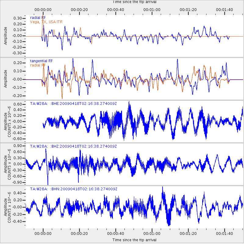
W28A Vega, TX, USA - Earthquake Result Viewer
*The percent match for this event was below the threshold and hence no stack was calculated.
| Earthquake location: |
Kermadec Islands Region |
| Earthquake latitude/longitude: |
-28.9/-177.4 |
| Earthquake time(UTC): |
2009/04/18 (108) 02:03:52 GMT |
| Earthquake Depth: |
65 km |
| Earthquake Magnitude: |
6.0 MB, 5.8 MW, 5.7 MW |
| Earthquake Catalog/Contributor: |
WHDF/NEIC |
|
| Network: |
TA USArray Transportable Network (new EarthScope stations) |
| Station: |
W28A Vega, TX, USA |
| Lat/Lon: |
35.26 N/102.21 W |
| Elevation: |
1156 m |
|
| Distance: |
95.4 deg |
| Az: |
52.643 deg |
| Baz: |
238.376 deg |
| Ray Param: |
$rayparam |
*The percent match for this event was below the threshold and hence was not used in the summary stack. |
|
| Radial Match: |
42.177944 % |
| Radial Bump: |
400 |
| Transverse Match: |
41.190166 % |
| Transverse Bump: |
400 |
| SOD ConfigId: |
2658 |
| Insert Time: |
2010-03-05 23:06:59.449 +0000 |
| GWidth: |
2.5 |
| Max Bumps: |
400 |
| Tol: |
0.001 |
|
Signal To Noise
| Channel | StoN | STA | LTA |
| TA:W28A: :BHZ:20090418T02:16:38.274009Z | 2.2163272 | 3.3249543E-7 | 1.5002091E-7 |
| TA:W28A: :BHN:20090418T02:16:38.274009Z | 1.2665726 | 1.5971274E-7 | 1.2609837E-7 |
| TA:W28A: :BHE:20090418T02:16:38.274009Z | 1.7896682 | 2.2533982E-7 | 1.259115E-7 |
| Arrivals |
| Ps | |
| PpPs | |
| PsPs/PpSs | |


