You are here: Home > Network List > TA - USArray Transportable Network (new EarthScope stations) Stations List
> Station P17K Kvichak River, AK, USA > Earthquake Result Viewer
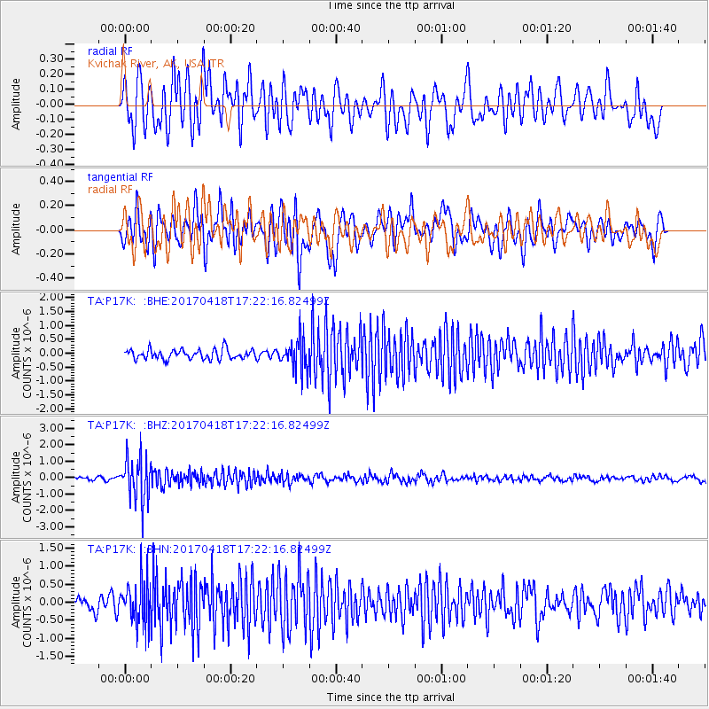
P17K Kvichak River, AK, USA - Earthquake Result Viewer
*The percent match for this event was below the threshold and hence no stack was calculated.
| Earthquake location: |
Fiji Islands Region |
| Earthquake latitude/longitude: |
-18.1/-178.4 |
| Earthquake time(UTC): |
2017/04/18 (108) 17:11:47 GMT |
| Earthquake Depth: |
626 km |
| Earthquake Magnitude: |
6.0 Mww |
| Earthquake Catalog/Contributor: |
NEIC PDE/us |
|
| Network: |
TA USArray Transportable Network (new EarthScope stations) |
| Station: |
P17K Kvichak River, AK, USA |
| Lat/Lon: |
59.20 N/156.44 W |
| Elevation: |
91 m |
|
| Distance: |
79.0 deg |
| Az: |
11.304 deg |
| Baz: |
201.244 deg |
| Ray Param: |
$rayparam |
*The percent match for this event was below the threshold and hence was not used in the summary stack. |
|
| Radial Match: |
74.25077 % |
| Radial Bump: |
400 |
| Transverse Match: |
71.98435 % |
| Transverse Bump: |
400 |
| SOD ConfigId: |
11737051 |
| Insert Time: |
2019-04-27 03:29:29.925 +0000 |
| GWidth: |
2.5 |
| Max Bumps: |
400 |
| Tol: |
0.001 |
|
Signal To Noise
| Channel | StoN | STA | LTA |
| TA:P17K: :BHZ:20170418T17:22:16.82499Z | 8.92966 | 1.3362452E-6 | 1.4964121E-7 |
| TA:P17K: :BHN:20170418T17:22:16.82499Z | 3.5927348 | 6.07443E-7 | 1.6907538E-7 |
| TA:P17K: :BHE:20170418T17:22:16.82499Z | 3.1398308 | 5.543818E-7 | 1.7656423E-7 |
| Arrivals |
| Ps | |
| PpPs | |
| PsPs/PpSs | |


