You are here: Home > Network List > US - United States National Seismic Network Stations List
> Station ERPA Erie, Pennsylvania, USA > Earthquake Result Viewer
ERPA Erie, Pennsylvania, USA - Earthquake Result Viewer
| Earthquake location: |
Peru-Brazil Border Region |
| Earthquake latitude/longitude: |
-10.6/-71.0 |
| Earthquake time(UTC): |
2015/11/24 (328) 22:45:38 GMT |
| Earthquake Depth: |
602 km |
| Earthquake Magnitude: |
7.5 MWW, 6.9 MI |
| Earthquake Catalog/Contributor: |
NEIC PDE/NEIC COMCAT |
|
| Network: |
US United States National Seismic Network |
| Station: |
ERPA Erie, Pennsylvania, USA |
| Lat/Lon: |
42.12 N/79.99 W |
| Elevation: |
306 m |
|
| Distance: |
53.1 deg |
| Az: |
351.609 deg |
| Baz: |
168.881 deg |
| Ray Param: |
0.06362387 |
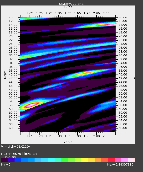
| Estimated Moho Depth: |
55.75 km |
| Estimated Crust Vp/Vs: |
1.66 |
| Assumed Crust Vp: |
6.419 km/s |
| Estimated Crust Vs: |
3.867 km/s |
| Estimated Crust Poisson's Ratio: |
0.22 |
|
| Radial Match: |
98.01104 % |
| Radial Bump: |
355 |
| Transverse Match: |
88.61605 % |
| Transverse Bump: |
400 |
| SOD ConfigId: |
1259291 |
| Insert Time: |
2015-12-08 23:44:39.582 +0000 |
| GWidth: |
2.5 |
| Max Bumps: |
400 |
| Tol: |
0.001 |
|

Signal To Noise
| Channel | StoN | STA | LTA |
| US:ERPA:00:BHZ:20151124T22:53:30.199008Z | 34.488377 | 2.4846431E-5 | 7.204291E-7 |
| US:ERPA:00:BH1:20151124T22:53:30.199008Z | 20.566824 | 1.0670465E-5 | 5.1881926E-7 |
| US:ERPA:00:BH2:20151124T22:53:30.199008Z | 7.5920954 | 3.0675683E-6 | 4.0404765E-7 |
| Arrivals |
| Ps | 6.0 SECOND |
| PpPs | 22 SECOND |
| PsPs/PpSs | 28 SECOND |


