You are here: Home > Network List > TA - USArray Transportable Network (new EarthScope stations) Stations List
> Station R33M Jennings River, BC, CAN > Earthquake Result Viewer
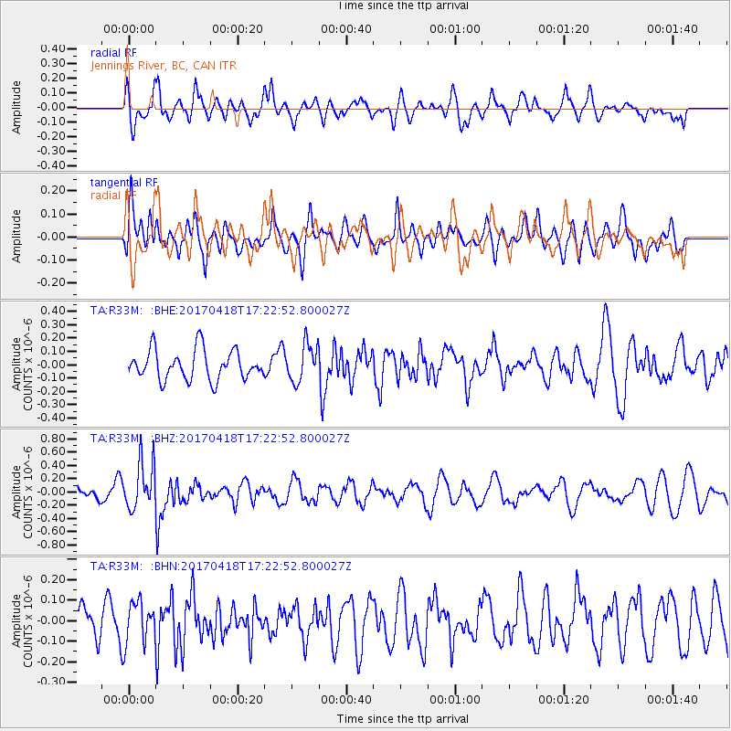
R33M Jennings River, BC, CAN - Earthquake Result Viewer
*The percent match for this event was below the threshold and hence no stack was calculated.
| Earthquake location: |
Fiji Islands Region |
| Earthquake latitude/longitude: |
-18.1/-178.4 |
| Earthquake time(UTC): |
2017/04/18 (108) 17:11:47 GMT |
| Earthquake Depth: |
626 km |
| Earthquake Magnitude: |
6.0 Mww |
| Earthquake Catalog/Contributor: |
NEIC PDE/us |
|
| Network: |
TA USArray Transportable Network (new EarthScope stations) |
| Station: |
R33M Jennings River, BC, CAN |
| Lat/Lon: |
59.39 N/130.97 W |
| Elevation: |
1437 m |
|
| Distance: |
86.3 deg |
| Az: |
22.185 deg |
| Baz: |
224.597 deg |
| Ray Param: |
$rayparam |
*The percent match for this event was below the threshold and hence was not used in the summary stack. |
|
| Radial Match: |
63.657413 % |
| Radial Bump: |
400 |
| Transverse Match: |
60.235924 % |
| Transverse Bump: |
400 |
| SOD ConfigId: |
11737051 |
| Insert Time: |
2019-04-27 03:29:45.021 +0000 |
| GWidth: |
2.5 |
| Max Bumps: |
400 |
| Tol: |
0.001 |
|
Signal To Noise
| Channel | StoN | STA | LTA |
| TA:R33M: :BHZ:20170418T17:22:52.800027Z | 5.022687 | 3.623268E-7 | 7.213804E-8 |
| TA:R33M: :BHN:20170418T17:22:52.800027Z | 1.0667273 | 1.0006607E-7 | 9.380661E-8 |
| TA:R33M: :BHE:20170418T17:22:52.800027Z | 1.2916666 | 1.4400096E-7 | 1.11484624E-7 |
| Arrivals |
| Ps | |
| PpPs | |
| PsPs/PpSs | |


