You are here: Home > Network List > TA - USArray Transportable Network (new EarthScope stations) Stations List
> Station 216A Three Points, Tucson, AZ, USA > Earthquake Result Viewer
216A Three Points, Tucson, AZ, USA - Earthquake Result Viewer
| Earthquake location: |
Peru-Brazil Border Region |
| Earthquake latitude/longitude: |
-7.6/-74.4 |
| Earthquake time(UTC): |
2008/08/26 (239) 21:00:36 GMT |
| Earthquake Depth: |
154 km |
| Earthquake Magnitude: |
6.0 MB, 6.4 MW, 6.4 MW |
| Earthquake Catalog/Contributor: |
WHDF/NEIC |
|
| Network: |
TA USArray Transportable Network (new EarthScope stations) |
| Station: |
216A Three Points, Tucson, AZ, USA |
| Lat/Lon: |
32.00 N/111.46 W |
| Elevation: |
908 m |
|
| Distance: |
53.0 deg |
| Az: |
320.084 deg |
| Baz: |
131.529 deg |
| Ray Param: |
0.06587848 |
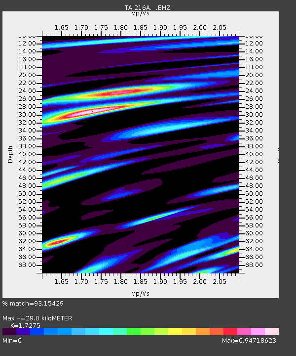
| Estimated Moho Depth: |
29.0 km |
| Estimated Crust Vp/Vs: |
1.73 |
| Assumed Crust Vp: |
6.276 km/s |
| Estimated Crust Vs: |
3.633 km/s |
| Estimated Crust Poisson's Ratio: |
0.25 |
|
| Radial Match: |
93.15429 % |
| Radial Bump: |
400 |
| Transverse Match: |
81.668724 % |
| Transverse Bump: |
400 |
| SOD ConfigId: |
2504 |
| Insert Time: |
2010-03-05 23:07:52.368 +0000 |
| GWidth: |
2.5 |
| Max Bumps: |
400 |
| Tol: |
0.001 |
|
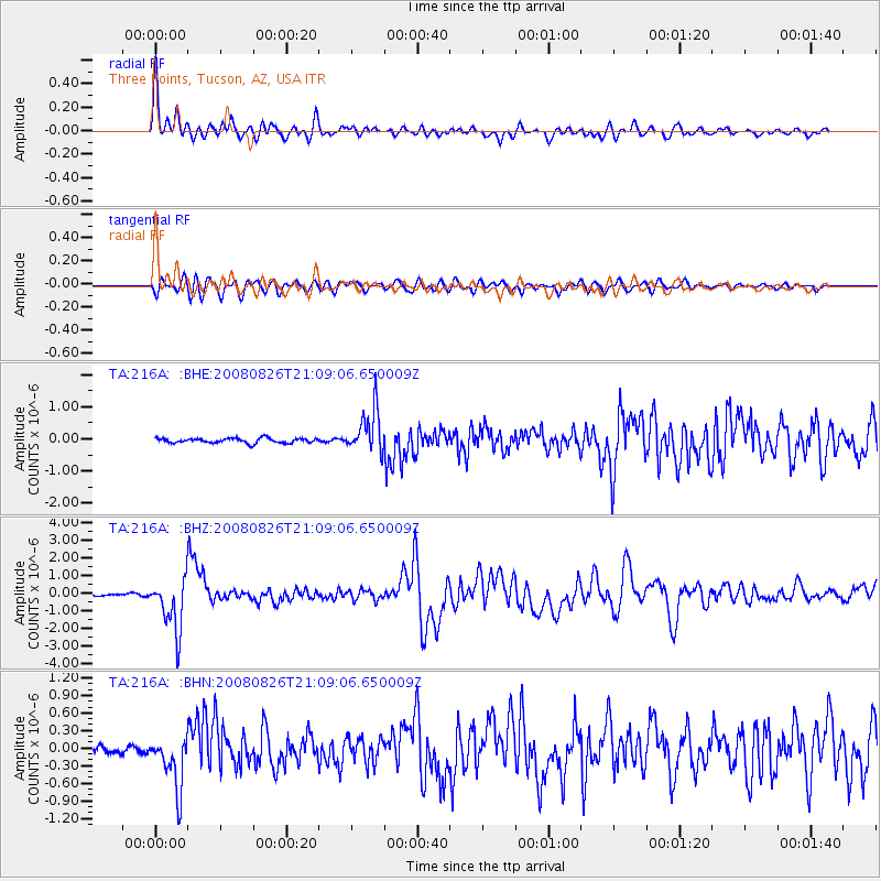
Signal To Noise
| Channel | StoN | STA | LTA |
| TA:216A: :BHZ:20080826T21:09:06.650009Z | 22.03731 | 1.5165548E-6 | 6.88176E-8 |
| TA:216A: :BHN:20080826T21:09:06.650009Z | 7.68832 | 4.539663E-7 | 5.9046222E-8 |
| TA:216A: :BHE:20080826T21:09:06.650009Z | 9.1673 | 6.6911747E-7 | 7.2989586E-8 |
| Arrivals |
| Ps | 3.5 SECOND |
| PpPs | 12 SECOND |
| PsPs/PpSs | 16 SECOND |


