You are here: Home > Network List > TA - USArray Transportable Network (new EarthScope stations) Stations List
> Station 216A Three Points, Tucson, AZ, USA > Earthquake Result Viewer
216A Three Points, Tucson, AZ, USA - Earthquake Result Viewer
| Earthquake location: |
Andreanof Islands, Aleutian Is. |
| Earthquake latitude/longitude: |
52.2/-178.7 |
| Earthquake time(UTC): |
2008/03/22 (082) 21:24:11 GMT |
| Earthquake Depth: |
132 km |
| Earthquake Magnitude: |
5.8 MB, 6.2 MW, 6.1 MW |
| Earthquake Catalog/Contributor: |
WHDF/NEIC |
|
| Network: |
TA USArray Transportable Network (new EarthScope stations) |
| Station: |
216A Three Points, Tucson, AZ, USA |
| Lat/Lon: |
32.00 N/111.46 W |
| Elevation: |
908 m |
|
| Distance: |
51.8 deg |
| Az: |
85.186 deg |
| Baz: |
313.76 deg |
| Ray Param: |
0.066705845 |
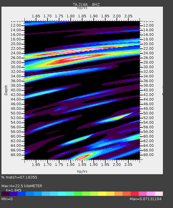
| Estimated Moho Depth: |
22.5 km |
| Estimated Crust Vp/Vs: |
1.85 |
| Assumed Crust Vp: |
6.276 km/s |
| Estimated Crust Vs: |
3.402 km/s |
| Estimated Crust Poisson's Ratio: |
0.29 |
|
| Radial Match: |
87.16355 % |
| Radial Bump: |
400 |
| Transverse Match: |
68.33145 % |
| Transverse Bump: |
400 |
| SOD ConfigId: |
2504 |
| Insert Time: |
2010-03-05 23:07:58.115 +0000 |
| GWidth: |
2.5 |
| Max Bumps: |
400 |
| Tol: |
0.001 |
|

Signal To Noise
| Channel | StoN | STA | LTA |
| TA:216A: :BHZ:20080322T21:32:35.323986Z | 16.685802 | 2.1015267E-6 | 1.25947E-7 |
| TA:216A: :BHN:20080322T21:32:35.323986Z | 6.666649 | 1.0278054E-6 | 1.5417123E-7 |
| TA:216A: :BHE:20080322T21:32:35.323986Z | 4.8770313 | 7.8091114E-7 | 1.6012018E-7 |
| Arrivals |
| Ps | 3.2 SECOND |
| PpPs | 9.7 SECOND |
| PsPs/PpSs | 13 SECOND |


