You are here: Home > Network List > US - United States National Seismic Network Stations List
> Station LBNH Lisbon, New Hampshire, USA > Earthquake Result Viewer
LBNH Lisbon, New Hampshire, USA - Earthquake Result Viewer
| Earthquake location: |
Peru-Brazil Border Region |
| Earthquake latitude/longitude: |
-10.6/-71.0 |
| Earthquake time(UTC): |
2015/11/24 (328) 22:45:38 GMT |
| Earthquake Depth: |
602 km |
| Earthquake Magnitude: |
7.5 MWW, 6.9 MI |
| Earthquake Catalog/Contributor: |
NEIC PDE/NEIC COMCAT |
|
| Network: |
US United States National Seismic Network |
| Station: |
LBNH Lisbon, New Hampshire, USA |
| Lat/Lon: |
44.24 N/71.93 W |
| Elevation: |
367 m |
|
| Distance: |
54.6 deg |
| Az: |
359.153 deg |
| Baz: |
178.841 deg |
| Ray Param: |
0.062729456 |
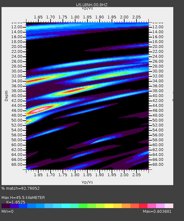
| Estimated Moho Depth: |
45.5 km |
| Estimated Crust Vp/Vs: |
1.65 |
| Assumed Crust Vp: |
6.419 km/s |
| Estimated Crust Vs: |
3.885 km/s |
| Estimated Crust Poisson's Ratio: |
0.21 |
|
| Radial Match: |
92.79852 % |
| Radial Bump: |
400 |
| Transverse Match: |
78.81394 % |
| Transverse Bump: |
400 |
| SOD ConfigId: |
1259291 |
| Insert Time: |
2015-12-08 23:45:42.566 +0000 |
| GWidth: |
2.5 |
| Max Bumps: |
400 |
| Tol: |
0.001 |
|

Signal To Noise
| Channel | StoN | STA | LTA |
| US:LBNH:00:BHZ:20151124T22:53:40.549014Z | 10.111125 | 9.8720575E-6 | 9.763561E-7 |
| US:LBNH:00:BH1:20151124T22:53:40.549014Z | 7.3190913 | 5.3131025E-6 | 7.2592377E-7 |
| US:LBNH:00:BH2:20151124T22:53:40.549014Z | 1.4733996 | 9.845669E-7 | 6.6822804E-7 |
| Arrivals |
| Ps | 4.9 SECOND |
| PpPs | 18 SECOND |
| PsPs/PpSs | 23 SECOND |


