You are here: Home > Network List > TA - USArray Transportable Network (new EarthScope stations) Stations List
> Station 216A Three Points, Tucson, AZ, USA > Earthquake Result Viewer
216A Three Points, Tucson, AZ, USA - Earthquake Result Viewer
| Earthquake location: |
Windward Islands |
| Earthquake latitude/longitude: |
15.0/-61.3 |
| Earthquake time(UTC): |
2007/11/29 (333) 19:00:19 GMT |
| Earthquake Depth: |
148 km |
| Earthquake Magnitude: |
6.9 MB, 7.4 MW, 7.4 MW |
| Earthquake Catalog/Contributor: |
WHDF/NEIC |
|
| Network: |
TA USArray Transportable Network (new EarthScope stations) |
| Station: |
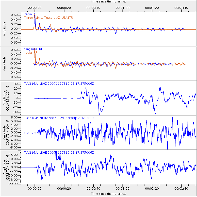
216A Three Points, Tucson, AZ, USA |
| Lat/Lon: |
32.00 N/111.46 W |
| Elevation: |
908 m |
|
| Distance: |
48.6 deg |
| Az: |
299.552 deg |
| Baz: |
98.289 deg |
| Ray Param: |
0.06871117 |
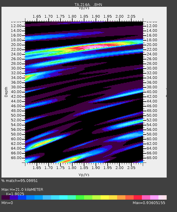
| Estimated Moho Depth: |
21.0 km |
| Estimated Crust Vp/Vs: |
1.90 |
| Assumed Crust Vp: |
6.276 km/s |
| Estimated Crust Vs: |
3.299 km/s |
| Estimated Crust Poisson's Ratio: |
0.31 |
|
| Radial Match: |
95.09951 % |
| Radial Bump: |
400 |
| Transverse Match: |
76.87342 % |
| Transverse Bump: |
400 |
| SOD ConfigId: |
2564 |
| Insert Time: |
2010-03-05 23:08:05.494 +0000 |
| GWidth: |
2.5 |
| Max Bumps: |
400 |
| Tol: |
0.001 |
|
Signal To Noise
| Channel | StoN | STA | LTA |
| TA:216A: :BHN:20071129T19:08:17.875006Z | 5.228342 | 8.0352817E-7 | 1.5368698E-7 |
| TA:216A: :BHE:20071129T19:08:17.875006Z | 23.816122 | 5.0115586E-6 | 2.1042715E-7 |
| TA:216A: :BHZ:20071129T19:08:17.875006Z | 32.734615 | 9.042099E-6 | 2.7622437E-7 |
| Arrivals |
| Ps | 3.2 SECOND |
| PpPs | 9.2 SECOND |
| PsPs/PpSs | 12 SECOND |


