You are here: Home > Network List > US - United States National Seismic Network Stations List
> Station LONY Lake Ozonia, New York, USA > Earthquake Result Viewer
LONY Lake Ozonia, New York, USA - Earthquake Result Viewer
| Earthquake location: |
Peru-Brazil Border Region |
| Earthquake latitude/longitude: |
-10.6/-71.0 |
| Earthquake time(UTC): |
2015/11/24 (328) 22:45:38 GMT |
| Earthquake Depth: |
602 km |
| Earthquake Magnitude: |
7.5 MWW, 6.9 MI |
| Earthquake Catalog/Contributor: |
NEIC PDE/NEIC COMCAT |
|
| Network: |
US United States National Seismic Network |
| Station: |
LONY Lake Ozonia, New York, USA |
| Lat/Lon: |
44.62 N/74.58 W |
| Elevation: |
440 m |
|
| Distance: |
55.0 deg |
| Az: |
356.848 deg |
| Baz: |
175.659 deg |
| Ray Param: |
0.062441524 |
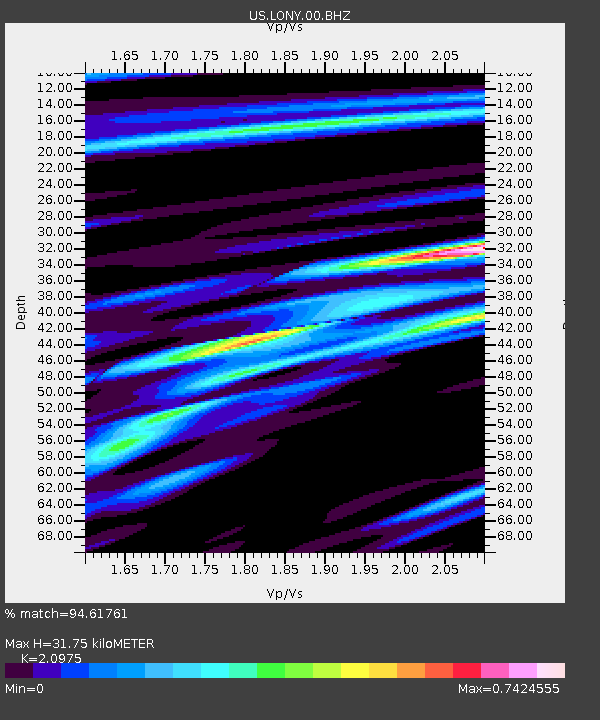
| Estimated Moho Depth: |
31.75 km |
| Estimated Crust Vp/Vs: |
2.10 |
| Assumed Crust Vp: |
6.419 km/s |
| Estimated Crust Vs: |
3.06 km/s |
| Estimated Crust Poisson's Ratio: |
0.35 |
|
| Radial Match: |
94.61761 % |
| Radial Bump: |
400 |
| Transverse Match: |
80.24347 % |
| Transverse Bump: |
400 |
| SOD ConfigId: |
1259291 |
| Insert Time: |
2015-12-08 23:45:50.128 +0000 |
| GWidth: |
2.5 |
| Max Bumps: |
400 |
| Tol: |
0.001 |
|
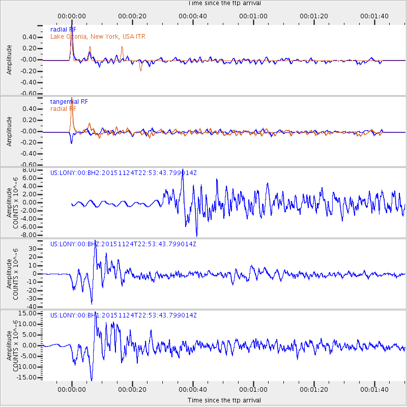
Signal To Noise
| Channel | StoN | STA | LTA |
| US:LONY:00:BHZ:20151124T22:53:43.799014Z | 15.383003 | 1.0216514E-5 | 6.64143E-7 |
| US:LONY:00:BH1:20151124T22:53:43.799014Z | 10.418437 | 4.449568E-6 | 4.2708595E-7 |
| US:LONY:00:BH2:20151124T22:53:43.799014Z | 4.2514544 | 1.8140316E-6 | 4.2668495E-7 |
| Arrivals |
| Ps | 5.7 SECOND |
| PpPs | 15 SECOND |
| PsPs/PpSs | 20 SECOND |


