You are here: Home > Network List > TA - USArray Transportable Network (new EarthScope stations) Stations List
> Station 216A Three Points, Tucson, AZ, USA > Earthquake Result Viewer
216A Three Points, Tucson, AZ, USA - Earthquake Result Viewer
| Earthquake location: |
Volcano Islands, Japan Region |
| Earthquake latitude/longitude: |
22.0/142.7 |
| Earthquake time(UTC): |
2007/09/28 (271) 13:38:59 GMT |
| Earthquake Depth: |
276 km |
| Earthquake Magnitude: |
6.7 MB, 7.4 MW, 7.4 MW |
| Earthquake Catalog/Contributor: |
WHDF/NEIC |
|
| Network: |
TA USArray Transportable Network (new EarthScope stations) |
| Station: |
216A Three Points, Tucson, AZ, USA |
| Lat/Lon: |
32.00 N/111.46 W |
| Elevation: |
908 m |
|
| Distance: |
91.1 deg |
| Az: |
54.816 deg |
| Baz: |
296.782 deg |
| Ray Param: |
0.041524164 |
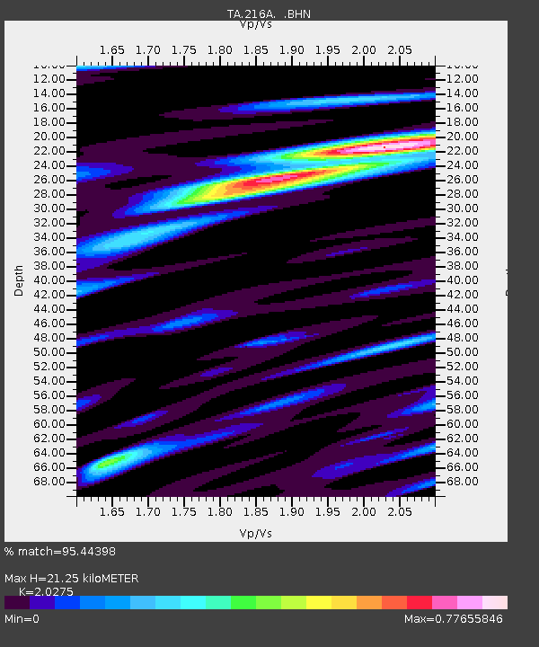
| Estimated Moho Depth: |
21.25 km |
| Estimated Crust Vp/Vs: |
2.03 |
| Assumed Crust Vp: |
6.276 km/s |
| Estimated Crust Vs: |
3.095 km/s |
| Estimated Crust Poisson's Ratio: |
0.34 |
|
| Radial Match: |
95.44398 % |
| Radial Bump: |
400 |
| Transverse Match: |
87.43476 % |
| Transverse Bump: |
400 |
| SOD ConfigId: |
2564 |
| Insert Time: |
2010-03-05 23:08:20.171 +0000 |
| GWidth: |
2.5 |
| Max Bumps: |
400 |
| Tol: |
0.001 |
|
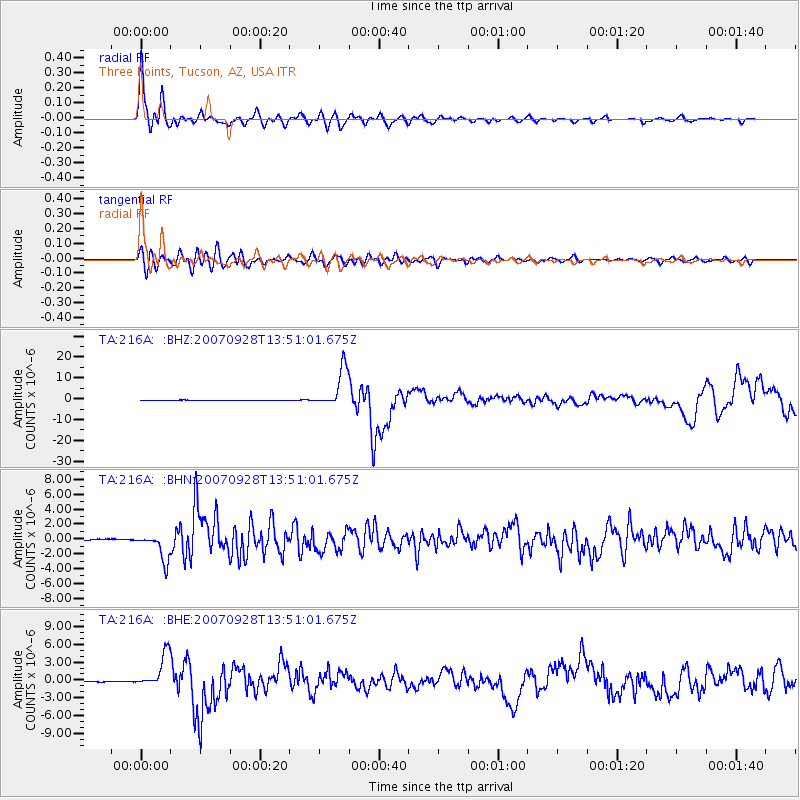
Signal To Noise
| Channel | StoN | STA | LTA |
| TA:216A: :BHN:20070928T13:51:01.675Z | 24.853167 | 1.819256E-6 | 7.320017E-8 |
| TA:216A: :BHE:20070928T13:51:01.675Z | 40.763767 | 2.860845E-6 | 7.018107E-8 |
| TA:216A: :BHZ:20070928T13:51:01.675Z | 86.909744 | 9.389811E-6 | 1.0804095E-7 |
| Arrivals |
| Ps | 3.5 SECOND |
| PpPs | 10 SECOND |
| PsPs/PpSs | 14 SECOND |


