You are here: Home > Network List > TA - USArray Transportable Network (new EarthScope stations) Stations List
> Station 216A Three Points, Tucson, AZ, USA > Earthquake Result Viewer
216A Three Points, Tucson, AZ, USA - Earthquake Result Viewer

| Earthquake location: |
Southeast Of Loyalty Islands |
| Earthquake latitude/longitude: |
-21.1/169.3 |
| Earthquake time(UTC): |
2007/09/27 (270) 19:57:44 GMT |
| Earthquake Depth: |
9.0 km |
| Earthquake Magnitude: |
6.2 MB, 6.3 MS, 6.1 MW, 6.1 MW |
| Earthquake Catalog/Contributor: |
WHDF/NEIC |
|
| Network: |
TA USArray Transportable Network (new EarthScope stations) |
| Station: |
216A Three Points, Tucson, AZ, USA |
| Lat/Lon: |
32.00 N/111.46 W |
| Elevation: |
908 m |
|
| Distance: |
92.3 deg |
| Az: |
56.661 deg |
| Baz: |
246.658 deg |
| Ray Param: |
0.041472454 |
| Estimated Moho Depth: |
49.25 km |
| Estimated Crust Vp/Vs: |
1.66 |
| Assumed Crust Vp: |
6.276 km/s |
| Estimated Crust Vs: |
3.769 km/s |
| Estimated Crust Poisson's Ratio: |
0.22 |
|
| Radial Match: |
84.07594 % |
| Radial Bump: |
400 |
| Transverse Match: |
67.92687 % |
| Transverse Bump: |
400 |
| SOD ConfigId: |
2564 |
| Insert Time: |
2010-03-05 23:08:22.645 +0000 |
| GWidth: |
2.5 |
| Max Bumps: |
400 |
| Tol: |
0.001 |
|
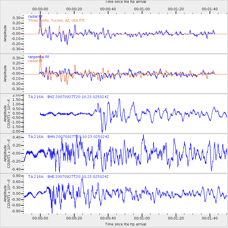
Signal To Noise
| Channel | StoN | STA | LTA |
| TA:216A: :BHN:20070927T20:10:23.025024Z | 0.6683026 | 6.587417E-8 | 9.856937E-8 |
| TA:216A: :BHE:20070927T20:10:23.025024Z | 1.8779502 | 1.5654493E-7 | 8.335947E-8 |
| TA:216A: :BHZ:20070927T20:10:23.025024Z | 5.242706 | 4.49489E-7 | 8.573607E-8 |
| Arrivals |
| Ps | 5.3 SECOND |
| PpPs | 20 SECOND |
| PsPs/PpSs | 26 SECOND |


