You are here: Home > Network List > TA - USArray Transportable Network (new EarthScope stations) Stations List
> Station 216A Three Points, Tucson, AZ, USA > Earthquake Result Viewer
216A Three Points, Tucson, AZ, USA - Earthquake Result Viewer
| Earthquake location: |
Near West Coast Of Colombia |
| Earthquake latitude/longitude: |
3.0/-78.0 |
| Earthquake time(UTC): |
2007/09/10 (253) 01:49:14 GMT |
| Earthquake Depth: |
31 km |
| Earthquake Magnitude: |
6.1 MB, 6.7 MS, 6.8 MW |
| Earthquake Catalog/Contributor: |
WHDF/NEIC |
|
| Network: |
TA USArray Transportable Network (new EarthScope stations) |
| Station: |
216A Three Points, Tucson, AZ, USA |
| Lat/Lon: |
32.00 N/111.46 W |
| Elevation: |
908 m |
|
| Distance: |
42.7 deg |
| Az: |
316.27 deg |
| Baz: |
125.657 deg |
| Ray Param: |
0.072958 |
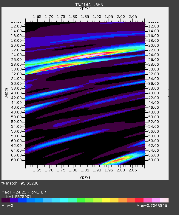
| Estimated Moho Depth: |
24.25 km |
| Estimated Crust Vp/Vs: |
1.86 |
| Assumed Crust Vp: |
6.276 km/s |
| Estimated Crust Vs: |
3.379 km/s |
| Estimated Crust Poisson's Ratio: |
0.30 |
|
| Radial Match: |
95.63288 % |
| Radial Bump: |
343 |
| Transverse Match: |
69.90562 % |
| Transverse Bump: |
400 |
| SOD ConfigId: |
2564 |
| Insert Time: |
2010-03-05 23:08:25.023 +0000 |
| GWidth: |
2.5 |
| Max Bumps: |
400 |
| Tol: |
0.001 |
|

Signal To Noise
| Channel | StoN | STA | LTA |
| TA:216A: :BHN:20070910T01:56:37.725005Z | 3.8449 | 5.311383E-7 | 1.3814099E-7 |
| TA:216A: :BHE:20070910T01:56:37.725005Z | 7.988574 | 7.6424755E-7 | 9.566758E-8 |
| TA:216A: :BHZ:20070910T01:56:37.725005Z | 12.044015 | 1.6619925E-6 | 1.3799324E-7 |
| Arrivals |
| Ps | 3.5 SECOND |
| PpPs | 10 SECOND |
| PsPs/PpSs | 14 SECOND |


