You are here: Home > Network List > AZ - ANZA Regional Network Stations List
> Station SMER AZ.SMER > Earthquake Result Viewer
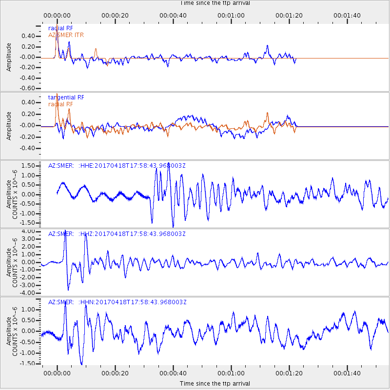
SMER AZ.SMER - Earthquake Result Viewer
*The percent match for this event was below the threshold and hence no stack was calculated.
| Earthquake location: |
Peru-Ecuador Border Region |
| Earthquake latitude/longitude: |
-2.7/-75.3 |
| Earthquake time(UTC): |
2017/04/18 (108) 17:49:55 GMT |
| Earthquake Depth: |
11 km |
| Earthquake Magnitude: |
6.0 Mww |
| Earthquake Catalog/Contributor: |
NEIC PDE/us |
|
| Network: |
AZ ANZA Regional Network |
| Station: |
SMER AZ.SMER |
| Lat/Lon: |
33.46 N/117.17 W |
| Elevation: |
355 m |
|
| Distance: |
53.4 deg |
| Az: |
315.99 deg |
| Baz: |
123.885 deg |
| Ray Param: |
$rayparam |
*The percent match for this event was below the threshold and hence was not used in the summary stack. |
|
| Radial Match: |
75.744 % |
| Radial Bump: |
400 |
| Transverse Match: |
44.733448 % |
| Transverse Bump: |
400 |
| SOD ConfigId: |
11737051 |
| Insert Time: |
2019-04-27 03:34:26.448 +0000 |
| GWidth: |
2.5 |
| Max Bumps: |
400 |
| Tol: |
0.001 |
|
Signal To Noise
| Channel | StoN | STA | LTA |
| AZ:SMER: :HHZ:20170418T17:58:43.968003Z | 11.376718 | 1.8189255E-6 | 1.598814E-7 |
| AZ:SMER: :HHN:20170418T17:58:43.968003Z | 3.4024935 | 6.2944946E-7 | 1.8499651E-7 |
| AZ:SMER: :HHE:20170418T17:58:43.968003Z | 2.5513446 | 6.565328E-7 | 2.5732814E-7 |
| Arrivals |
| Ps | |
| PpPs | |
| PsPs/PpSs | |


