You are here: Home > Network List > TA - USArray Transportable Network (new EarthScope stations) Stations List
> Station 216A Three Points, Tucson, AZ, USA > Earthquake Result Viewer
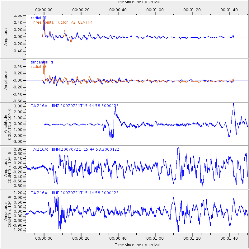
216A Three Points, Tucson, AZ, USA - Earthquake Result Viewer

| Earthquake location: |
Jujuy Province, Argentina |
| Earthquake latitude/longitude: |
-22.2/-65.8 |
| Earthquake time(UTC): |
2007/07/21 (202) 15:34:52 GMT |
| Earthquake Depth: |
290 km |
| Earthquake Magnitude: |
5.8 MB, 6.4 MW, 6.3 MW |
| Earthquake Catalog/Contributor: |
WHDF/NEIC |
|
| Network: |
TA USArray Transportable Network (new EarthScope stations) |
| Station: |
216A Three Points, Tucson, AZ, USA |
| Lat/Lon: |
32.00 N/111.46 W |
| Elevation: |
908 m |
|
| Distance: |
69.4 deg |
| Az: |
319.49 deg |
| Baz: |
134.863 deg |
| Ray Param: |
0.05483415 |
| Estimated Moho Depth: |
61.0 km |
| Estimated Crust Vp/Vs: |
1.63 |
| Assumed Crust Vp: |
6.276 km/s |
| Estimated Crust Vs: |
3.844 km/s |
| Estimated Crust Poisson's Ratio: |
0.20 |
|
| Radial Match: |
93.87818 % |
| Radial Bump: |
373 |
| Transverse Match: |
72.98626 % |
| Transverse Bump: |
400 |
| SOD ConfigId: |
2564 |
| Insert Time: |
2010-03-05 23:08:44.650 +0000 |
| GWidth: |
2.5 |
| Max Bumps: |
400 |
| Tol: |
0.001 |
|
Signal To Noise
| Channel | StoN | STA | LTA |
| TA:216A: :BHN:20070721T15:44:58.300012Z | 2.2529957 | 1.0764258E-7 | 4.7777533E-8 |
| TA:216A: :BHE:20070721T15:44:58.300012Z | 3.037381 | 2.0150408E-7 | 6.634139E-8 |
| TA:216A: :BHZ:20070721T15:44:58.300012Z | 5.0768113 | 3.7805634E-7 | 7.446729E-8 |
| Arrivals |
| Ps | 6.4 SECOND |
| PpPs | 25 SECOND |
| PsPs/PpSs | 31 SECOND |


