You are here: Home > Network List > US - United States National Seismic Network Stations List
> Station PKME Peaks-Kenny State Park, Maine, USA > Earthquake Result Viewer
PKME Peaks-Kenny State Park, Maine, USA - Earthquake Result Viewer
| Earthquake location: |
Peru-Brazil Border Region |
| Earthquake latitude/longitude: |
-10.6/-71.0 |
| Earthquake time(UTC): |
2015/11/24 (328) 22:45:38 GMT |
| Earthquake Depth: |
602 km |
| Earthquake Magnitude: |
7.5 MWW, 6.9 MI |
| Earthquake Catalog/Contributor: |
NEIC PDE/NEIC COMCAT |
|
| Network: |
US United States National Seismic Network |
| Station: |
PKME Peaks-Kenny State Park, Maine, USA |
| Lat/Lon: |
45.26 N/69.29 W |
| Elevation: |
108 m |
|
| Distance: |
55.6 deg |
| Az: |
1.433 deg |
| Baz: |
181.995 deg |
| Ray Param: |
0.06208938 |
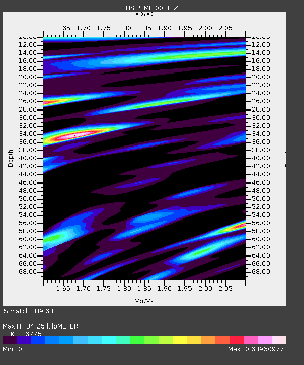
| Estimated Moho Depth: |
34.25 km |
| Estimated Crust Vp/Vs: |
1.68 |
| Assumed Crust Vp: |
6.419 km/s |
| Estimated Crust Vs: |
3.827 km/s |
| Estimated Crust Poisson's Ratio: |
0.22 |
|
| Radial Match: |
89.68 % |
| Radial Bump: |
364 |
| Transverse Match: |
82.28661 % |
| Transverse Bump: |
400 |
| SOD ConfigId: |
1259291 |
| Insert Time: |
2015-12-08 23:46:39.772 +0000 |
| GWidth: |
2.5 |
| Max Bumps: |
400 |
| Tol: |
0.001 |
|

Signal To Noise
| Channel | StoN | STA | LTA |
| US:PKME:00:BHZ:20151124T22:53:47.725009Z | 11.19074 | 1.0740424E-5 | 9.5976E-7 |
| US:PKME:00:BH1:20151124T22:53:47.725009Z | 9.47012 | 5.3825897E-6 | 5.6837604E-7 |
| US:PKME:00:BH2:20151124T22:53:47.725009Z | 1.6507381 | 1.1047845E-6 | 6.6926697E-7 |
| Arrivals |
| Ps | 3.8 SECOND |
| PpPs | 14 SECOND |
| PsPs/PpSs | 17 SECOND |


