You are here: Home > Network List > C1 - Red Sismologica Nacional Stations List
> Station BO02 Daracena > Earthquake Result Viewer
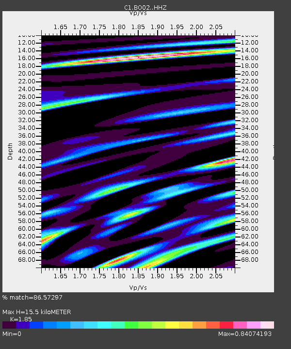
BO02 Daracena - Earthquake Result Viewer
| Earthquake location: |
Peru-Ecuador Border Region |
| Earthquake latitude/longitude: |
-2.7/-75.3 |
| Earthquake time(UTC): |
2017/04/18 (108) 17:49:55 GMT |
| Earthquake Depth: |
11 km |
| Earthquake Magnitude: |
6.0 Mww |
| Earthquake Catalog/Contributor: |
NEIC PDE/us |
|
| Network: |
C1 Red Sismologica Nacional |
| Station: |
BO02 Daracena |
| Lat/Lon: |
34.79 S/70.78 W |
| Elevation: |
886 m |
|
| Distance: |
32.2 deg |
| Az: |
172.999 deg |
| Baz: |
351.493 deg |
| Ray Param: |
0.07875997 |
| Estimated Moho Depth: |
15.5 km |
| Estimated Crust Vp/Vs: |
1.85 |
| Assumed Crust Vp: |
6.481 km/s |
| Estimated Crust Vs: |
3.503 km/s |
| Estimated Crust Poisson's Ratio: |
0.29 |
|
| Radial Match: |
86.57297 % |
| Radial Bump: |
400 |
| Transverse Match: |
76.70488 % |
| Transverse Bump: |
400 |
| SOD ConfigId: |
11737051 |
| Insert Time: |
2019-04-27 03:34:52.428 +0000 |
| GWidth: |
2.5 |
| Max Bumps: |
400 |
| Tol: |
0.001 |
|

Signal To Noise
| Channel | StoN | STA | LTA |
| C1:BO02: :HHZ:20170418T17:55:52.517991Z | 14.414001 | 2.1175272E-6 | 1.4690767E-7 |
| C1:BO02: :HHN:20170418T17:55:52.517991Z | 7.4976854 | 1.3320423E-6 | 1.7766047E-7 |
| C1:BO02: :HHE:20170418T17:55:52.517991Z | 6.8761115 | 7.5468915E-7 | 1.0975522E-7 |
| Arrivals |
| Ps | 2.2 SECOND |
| PpPs | 6.3 SECOND |
| PsPs/PpSs | 8.5 SECOND |


