You are here: Home > Network List > US - United States National Seismic Network Stations List
> Station WRAK Wrangell Island, Southeastern Alaska, Alaska, USA > Earthquake Result Viewer
WRAK Wrangell Island, Southeastern Alaska, Alaska, USA - Earthquake Result Viewer
| Earthquake location: |
Peru-Brazil Border Region |
| Earthquake latitude/longitude: |
-10.6/-71.0 |
| Earthquake time(UTC): |
2015/11/24 (328) 22:45:38 GMT |
| Earthquake Depth: |
602 km |
| Earthquake Magnitude: |
7.5 MWW, 6.9 MI |
| Earthquake Catalog/Contributor: |
NEIC PDE/NEIC COMCAT |
|
| Network: |
US United States National Seismic Network |
| Station: |
WRAK Wrangell Island, Southeastern Alaska, Alaska, USA |
| Lat/Lon: |
56.42 N/132.35 W |
| Elevation: |
81 m |
|
| Distance: |
83.7 deg |
| Az: |
330.608 deg |
| Baz: |
119.733 deg |
| Ray Param: |
0.04421853 |
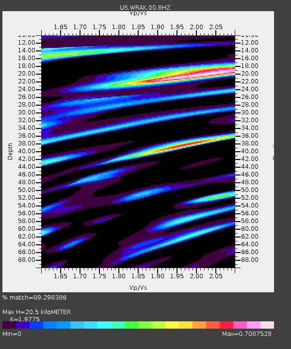
| Estimated Moho Depth: |
20.5 km |
| Estimated Crust Vp/Vs: |
1.98 |
| Assumed Crust Vp: |
6.597 km/s |
| Estimated Crust Vs: |
3.336 km/s |
| Estimated Crust Poisson's Ratio: |
0.33 |
|
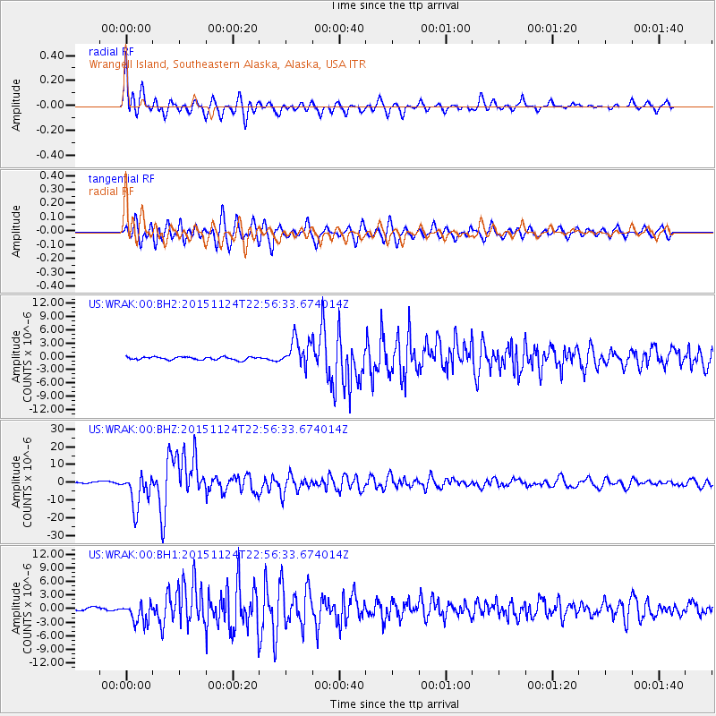
| Radial Match: |
89.298386 % |
| Radial Bump: |
400 |
| Transverse Match: |
74.341 % |
| Transverse Bump: |
400 |
| SOD ConfigId: |
1259291 |
| Insert Time: |
2015-12-08 23:47:04.746 +0000 |
| GWidth: |
2.5 |
| Max Bumps: |
400 |
| Tol: |
0.001 |
|
Signal To Noise
| Channel | StoN | STA | LTA |
| US:WRAK:00:BHZ:20151124T22:56:33.674014Z | 18.34622 | 9.861333E-6 | 5.37513E-7 |
| US:WRAK:00:BH1:20151124T22:56:33.674014Z | 7.592627 | 2.2629424E-6 | 2.980447E-7 |
| US:WRAK:00:BH2:20151124T22:56:33.674014Z | 9.749775 | 3.1842499E-6 | 3.2659727E-7 |
| Arrivals |
| Ps | 3.1 SECOND |
| PpPs | 9.0 SECOND |
| PsPs/PpSs | 12 SECOND |


