You are here: Home > Network List > CI - Caltech Regional Seismic Network Stations List
> Station DEC Green Verdugo Microwave Site, Sunland, CA, USA > Earthquake Result Viewer
DEC Green Verdugo Microwave Site, Sunland, CA, USA - Earthquake Result Viewer
| Earthquake location: |
Peru-Ecuador Border Region |
| Earthquake latitude/longitude: |
-2.7/-75.3 |
| Earthquake time(UTC): |
2017/04/18 (108) 17:49:55 GMT |
| Earthquake Depth: |
11 km |
| Earthquake Magnitude: |
6.0 Mww |
| Earthquake Catalog/Contributor: |
NEIC PDE/us |
|
| Network: |
CI Caltech Regional Seismic Network |
| Station: |
DEC Green Verdugo Microwave Site, Sunland, CA, USA |
| Lat/Lon: |
34.25 N/118.33 W |
| Elevation: |
519 m |
|
| Distance: |
54.7 deg |
| Az: |
316.145 deg |
| Baz: |
123.331 deg |
| Ray Param: |
0.06530414 |
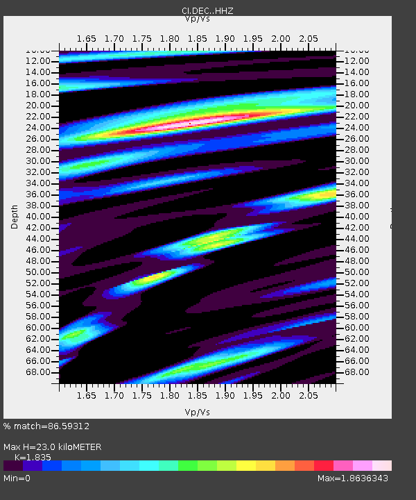
| Estimated Moho Depth: |
23.0 km |
| Estimated Crust Vp/Vs: |
1.84 |
| Assumed Crust Vp: |
6.1 km/s |
| Estimated Crust Vs: |
3.324 km/s |
| Estimated Crust Poisson's Ratio: |
0.29 |
|
| Radial Match: |
86.59312 % |
| Radial Bump: |
400 |
| Transverse Match: |
85.427345 % |
| Transverse Bump: |
400 |
| SOD ConfigId: |
11737051 |
| Insert Time: |
2019-04-27 03:35:41.743 +0000 |
| GWidth: |
2.5 |
| Max Bumps: |
400 |
| Tol: |
0.001 |
|

Signal To Noise
| Channel | StoN | STA | LTA |
| CI:DEC: :HHZ:20170418T17:58:53.03801Z | 15.321267 | 3.819757E-6 | 2.4931077E-7 |
| CI:DEC: :HHN:20170418T17:58:53.03801Z | 1.6804153 | 8.0872866E-7 | 4.8126714E-7 |
| CI:DEC: :HHE:20170418T17:58:53.03801Z | 5.618432 | 1.4915112E-6 | 2.6546752E-7 |
| Arrivals |
| Ps | 3.3 SECOND |
| PpPs | 10 SECOND |
| PsPs/PpSs | 14 SECOND |


