You are here: Home > Network List > TA - USArray Transportable Network (new EarthScope stations) Stations List
> Station 216A Three Points, Tucson, AZ, USA > Earthquake Result Viewer
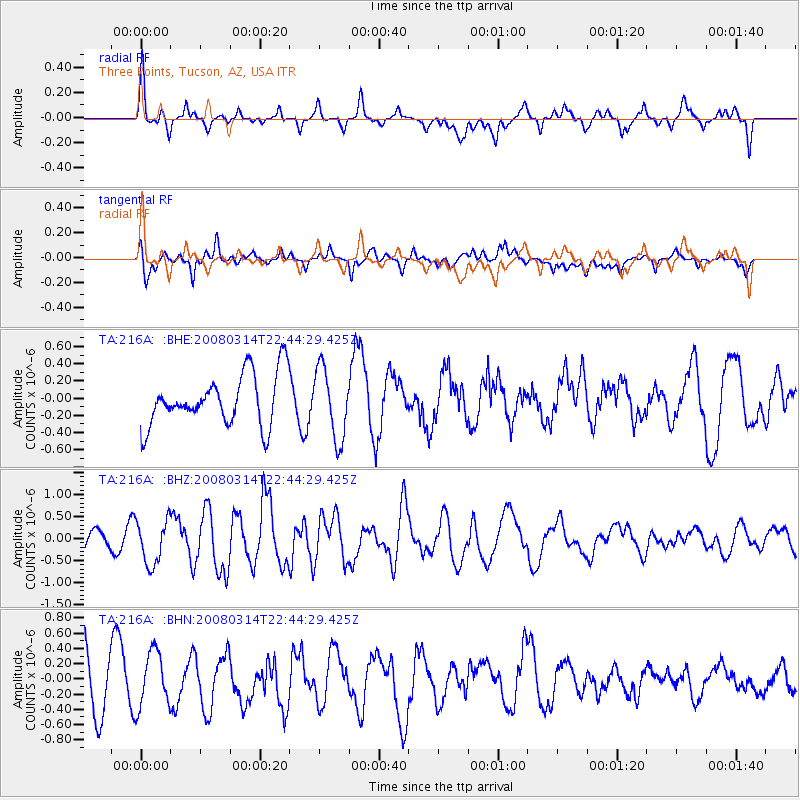
216A Three Points, Tucson, AZ, USA - Earthquake Result Viewer
*The percent match for this event was below the threshold and hence no stack was calculated.
| Earthquake location: |
Bonin Islands, Japan Region |
| Earthquake latitude/longitude: |
27.0/142.6 |
| Earthquake time(UTC): |
2008/03/14 (074) 22:32:09 GMT |
| Earthquake Depth: |
11 km |
| Earthquake Magnitude: |
5.7 MB, 5.9 MS, 6.0 MW, 6.0 MW |
| Earthquake Catalog/Contributor: |
WHDF/NEIC |
|
| Network: |
TA USArray Transportable Network (new EarthScope stations) |
| Station: |
216A Three Points, Tucson, AZ, USA |
| Lat/Lon: |
32.00 N/111.46 W |
| Elevation: |
908 m |
|
| Distance: |
88.3 deg |
| Az: |
54.815 deg |
| Baz: |
300.864 deg |
| Ray Param: |
$rayparam |
*The percent match for this event was below the threshold and hence was not used in the summary stack. |
|
| Radial Match: |
63.058258 % |
| Radial Bump: |
400 |
| Transverse Match: |
47.97002 % |
| Transverse Bump: |
400 |
| SOD ConfigId: |
2504 |
| Insert Time: |
2010-03-05 23:09:18.100 +0000 |
| GWidth: |
2.5 |
| Max Bumps: |
400 |
| Tol: |
0.001 |
|
Signal To Noise
| Channel | StoN | STA | LTA |
| TA:216A: :BHZ:20080314T22:44:29.425Z | 3.4565437 | 5.0285803E-7 | 1.4548003E-7 |
| TA:216A: :BHN:20080314T22:44:29.425Z | 0.7588706 | 3.585337E-7 | 4.7245697E-7 |
| TA:216A: :BHE:20080314T22:44:29.425Z | 1.3777193 | 4.072928E-7 | 2.9562827E-7 |
| Arrivals |
| Ps | |
| PpPs | |
| PsPs/PpSs | |


