You are here: Home > Network List > CI - Caltech Regional Seismic Network Stations List
> Station MPP McPhearson Peak > Earthquake Result Viewer
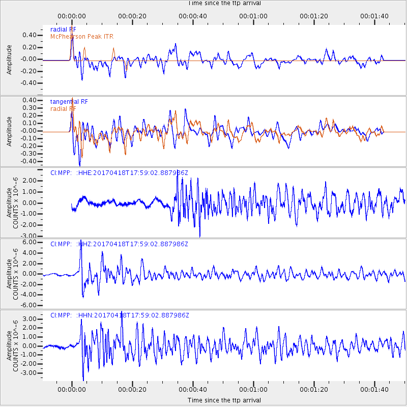
MPP McPhearson Peak - Earthquake Result Viewer
*The percent match for this event was below the threshold and hence no stack was calculated.
| Earthquake location: |
Peru-Ecuador Border Region |
| Earthquake latitude/longitude: |
-2.7/-75.3 |
| Earthquake time(UTC): |
2017/04/18 (108) 17:49:55 GMT |
| Earthquake Depth: |
11 km |
| Earthquake Magnitude: |
6.0 Mww |
| Earthquake Catalog/Contributor: |
NEIC PDE/us |
|
| Network: |
CI Caltech Regional Seismic Network |
| Station: |
MPP McPhearson Peak |
| Lat/Lon: |
34.89 N/119.81 W |
| Elevation: |
1739 m |
|
| Distance: |
56.0 deg |
| Az: |
315.986 deg |
| Baz: |
122.404 deg |
| Ray Param: |
$rayparam |
*The percent match for this event was below the threshold and hence was not used in the summary stack. |
|
| Radial Match: |
80.812614 % |
| Radial Bump: |
400 |
| Transverse Match: |
71.03325 % |
| Transverse Bump: |
400 |
| SOD ConfigId: |
11737051 |
| Insert Time: |
2019-04-27 03:36:07.146 +0000 |
| GWidth: |
2.5 |
| Max Bumps: |
400 |
| Tol: |
0.001 |
|
Signal To Noise
| Channel | StoN | STA | LTA |
| CI:MPP: :HHZ:20170418T17:59:02.887986Z | 16.767384 | 2.2880215E-6 | 1.3645668E-7 |
| CI:MPP: :HHN:20170418T17:59:02.887986Z | 5.8697066 | 1.2821145E-6 | 2.1842907E-7 |
| CI:MPP: :HHE:20170418T17:59:02.887986Z | 2.5408936 | 6.3195205E-7 | 2.4871252E-7 |
| Arrivals |
| Ps | |
| PpPs | |
| PsPs/PpSs | |


