You are here: Home > Network List > CI - Caltech Regional Seismic Network Stations List
> Station NEE2 Needles Airport > Earthquake Result Viewer
NEE2 Needles Airport - Earthquake Result Viewer
| Earthquake location: |
Peru-Ecuador Border Region |
| Earthquake latitude/longitude: |
-2.7/-75.3 |
| Earthquake time(UTC): |
2017/04/18 (108) 17:49:55 GMT |
| Earthquake Depth: |
11 km |
| Earthquake Magnitude: |
6.0 Mww |
| Earthquake Catalog/Contributor: |
NEIC PDE/us |
|
| Network: |
CI Caltech Regional Seismic Network |
| Station: |
NEE2 Needles Airport |
| Lat/Lon: |
34.77 N/114.62 W |
| Elevation: |
271 m |
|
| Distance: |
52.5 deg |
| Az: |
318.863 deg |
| Baz: |
127.041 deg |
| Ray Param: |
0.06674783 |
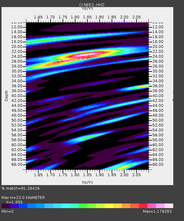
| Estimated Moho Depth: |
23.0 km |
| Estimated Crust Vp/Vs: |
1.86 |
| Assumed Crust Vp: |
6.276 km/s |
| Estimated Crust Vs: |
3.383 km/s |
| Estimated Crust Poisson's Ratio: |
0.30 |
|
| Radial Match: |
91.26426 % |
| Radial Bump: |
400 |
| Transverse Match: |
77.38838 % |
| Transverse Bump: |
400 |
| SOD ConfigId: |
11737051 |
| Insert Time: |
2019-04-27 03:36:09.139 +0000 |
| GWidth: |
2.5 |
| Max Bumps: |
400 |
| Tol: |
0.001 |
|

Signal To Noise
| Channel | StoN | STA | LTA |
| CI:NEE2: :HHZ:20170418T17:58:36.837998Z | 11.673577 | 1.9072703E-6 | 1.6338353E-7 |
| CI:NEE2: :HHN:20170418T17:58:36.837998Z | 6.510383 | 9.414798E-7 | 1.4461205E-7 |
| CI:NEE2: :HHE:20170418T17:58:36.837998Z | 7.563401 | 1.203798E-6 | 1.5916093E-7 |
| Arrivals |
| Ps | 3.3 SECOND |
| PpPs | 10.0 SECOND |
| PsPs/PpSs | 13 SECOND |


