You are here: Home > Network List > TA - USArray Transportable Network (new EarthScope stations) Stations List
> Station 216A Three Points, Tucson, AZ, USA > Earthquake Result Viewer
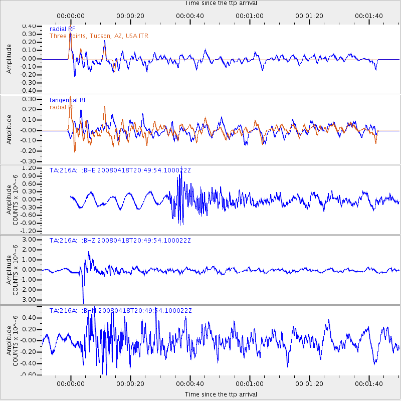
216A Three Points, Tucson, AZ, USA - Earthquake Result Viewer
*The percent match for this event was below the threshold and hence no stack was calculated.
| Earthquake location: |
Fiji Islands Region |
| Earthquake latitude/longitude: |
-17.3/-179.0 |
| Earthquake time(UTC): |
2008/04/18 (109) 20:39:07 GMT |
| Earthquake Depth: |
554 km |
| Earthquake Magnitude: |
5.9 MB, 6.3 MW, 6.3 MW |
| Earthquake Catalog/Contributor: |
WHDF/NEIC |
|
| Network: |
TA USArray Transportable Network (new EarthScope stations) |
| Station: |
216A Three Points, Tucson, AZ, USA |
| Lat/Lon: |
32.00 N/111.46 W |
| Elevation: |
908 m |
|
| Distance: |
81.2 deg |
| Az: |
52.629 deg |
| Baz: |
243.303 deg |
| Ray Param: |
$rayparam |
*The percent match for this event was below the threshold and hence was not used in the summary stack. |
|
| Radial Match: |
56.77166 % |
| Radial Bump: |
400 |
| Transverse Match: |
74.39658 % |
| Transverse Bump: |
400 |
| SOD ConfigId: |
2504 |
| Insert Time: |
2010-03-05 23:09:21.264 +0000 |
| GWidth: |
2.5 |
| Max Bumps: |
400 |
| Tol: |
0.001 |
|
Signal To Noise
| Channel | StoN | STA | LTA |
| TA:216A: :BHZ:20080418T20:49:54.100022Z | 11.66935 | 8.75669E-7 | 7.504009E-8 |
| TA:216A: :BHN:20080418T20:49:54.100022Z | 1.5413684 | 1.2786286E-7 | 8.2954124E-8 |
| TA:216A: :BHE:20080418T20:49:54.100022Z | 1.295843 | 2.3665402E-7 | 1.8262554E-7 |
| Arrivals |
| Ps | |
| PpPs | |
| PsPs/PpSs | |


