You are here: Home > Network List > CN - Canadian National Seismograph Network Stations List
> Station KUKN Kugluktuk, NT, CA > Earthquake Result Viewer
KUKN Kugluktuk, NT, CA - Earthquake Result Viewer
| Earthquake location: |
Peru-Ecuador Border Region |
| Earthquake latitude/longitude: |
-2.7/-75.3 |
| Earthquake time(UTC): |
2017/04/18 (108) 17:49:55 GMT |
| Earthquake Depth: |
11 km |
| Earthquake Magnitude: |
6.0 Mww |
| Earthquake Catalog/Contributor: |
NEIC PDE/us |
|
| Network: |
CN Canadian National Seismograph Network |
| Station: |
KUKN Kugluktuk, NT, CA |
| Lat/Lon: |
67.82 N/115.09 W |
| Elevation: |
51 m |
|
| Distance: |
75.7 deg |
| Az: |
345.478 deg |
| Baz: |
138.719 deg |
| Ray Param: |
0.05151861 |
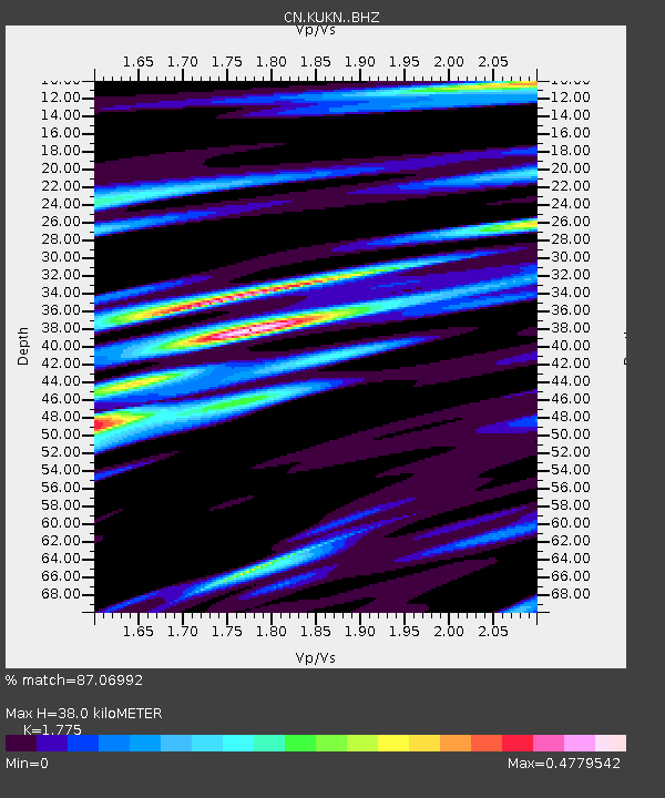
| Estimated Moho Depth: |
38.0 km |
| Estimated Crust Vp/Vs: |
1.77 |
| Assumed Crust Vp: |
6.459 km/s |
| Estimated Crust Vs: |
3.639 km/s |
| Estimated Crust Poisson's Ratio: |
0.27 |
|
| Radial Match: |
87.06992 % |
| Radial Bump: |
400 |
| Transverse Match: |
75.845375 % |
| Transverse Bump: |
400 |
| SOD ConfigId: |
11737051 |
| Insert Time: |
2019-04-27 03:37:06.933 +0000 |
| GWidth: |
2.5 |
| Max Bumps: |
400 |
| Tol: |
0.001 |
|

Signal To Noise
| Channel | StoN | STA | LTA |
| CN:KUKN: :BHZ:20170418T18:01:08.975022Z | 14.691348 | 1.6848264E-6 | 1.1468154E-7 |
| CN:KUKN: :BHN:20170418T18:01:08.975022Z | 4.250342 | 4.828223E-7 | 1.1359612E-7 |
| CN:KUKN: :BHE:20170418T18:01:08.975022Z | 4.7047005 | 4.3492702E-7 | 9.2445205E-8 |
| Arrivals |
| Ps | 4.7 SECOND |
| PpPs | 16 SECOND |
| PsPs/PpSs | 21 SECOND |


