You are here: Home > Network List > CI - Caltech Regional Seismic Network Stations List
> Station MWC Mt. Wilson Observatory, Altadena, CA, USA > Earthquake Result Viewer
MWC Mt. Wilson Observatory, Altadena, CA, USA - Earthquake Result Viewer

| Earthquake location: |
Tonga Islands |
| Earthquake latitude/longitude: |
-20.2/-174.1 |
| Earthquake time(UTC): |
2006/05/03 (123) 15:26:40 GMT |
| Earthquake Depth: |
55 km |
| Earthquake Magnitude: |
7.2 MB, 7.8 MS, 7.9 MW, 7.9 MW |
| Earthquake Catalog/Contributor: |
WHDF/NEIC |
|
| Network: |
CI Caltech Regional Seismic Network |
| Station: |
MWC Mt. Wilson Observatory, Altadena, CA, USA |
| Lat/Lon: |
34.22 N/118.06 W |
| Elevation: |
1725 m |
|
| Distance: |
76.0 deg |
| Az: |
45.121 deg |
| Baz: |
233.445 deg |
| Ray Param: |
0.05120304 |
| Estimated Moho Depth: |
40.75 km |
| Estimated Crust Vp/Vs: |
1.60 |
| Assumed Crust Vp: |
6.1 km/s |
| Estimated Crust Vs: |
3.812 km/s |
| Estimated Crust Poisson's Ratio: |
0.18 |
|
| Radial Match: |
95.42583 % |
| Radial Bump: |
396 |
| Transverse Match: |
91.32527 % |
| Transverse Bump: |
400 |
| SOD ConfigId: |
2669 |
| Insert Time: |
2010-02-26 01:07:17.784 +0000 |
| GWidth: |
2.5 |
| Max Bumps: |
400 |
| Tol: |
0.001 |
|
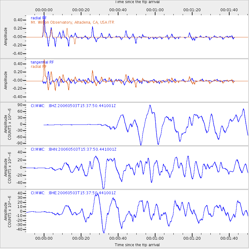
Signal To Noise
| Channel | StoN | STA | LTA |
| CI:MWC: :BHN:20060503T15:37:50.441001Z | 1.9341495 | 9.170223E-7 | 4.7412172E-7 |
| CI:MWC: :BHE:20060503T15:37:50.441001Z | 2.2275572 | 9.505023E-7 | 4.2670163E-7 |
| CI:MWC: :BHZ:20060503T15:37:50.441001Z | 6.485481 | 3.28249E-6 | 5.06129E-7 |
| Arrivals |
| Ps | 4.1 SECOND |
| PpPs | 17 SECOND |
| PsPs/PpSs | 21 SECOND |


