You are here: Home > Network List > UU - University of Utah Regional Network Stations List
> Station LCMT Little Creek Mountain, UT, USA > Earthquake Result Viewer
LCMT Little Creek Mountain, UT, USA - Earthquake Result Viewer
| Earthquake location: |
Peru-Brazil Border Region |
| Earthquake latitude/longitude: |
-10.6/-71.0 |
| Earthquake time(UTC): |
2015/11/24 (328) 22:45:38 GMT |
| Earthquake Depth: |
602 km |
| Earthquake Magnitude: |
7.5 MWW, 6.9 MI |
| Earthquake Catalog/Contributor: |
NEIC PDE/NEIC COMCAT |
|
| Network: |
UU University of Utah Regional Network |
| Station: |
LCMT Little Creek Mountain, UT, USA |
| Lat/Lon: |
37.01 N/113.24 W |
| Elevation: |
1411 m |
|
| Distance: |
61.8 deg |
| Az: |
322.328 deg |
| Baz: |
131.351 deg |
| Ray Param: |
0.05829837 |
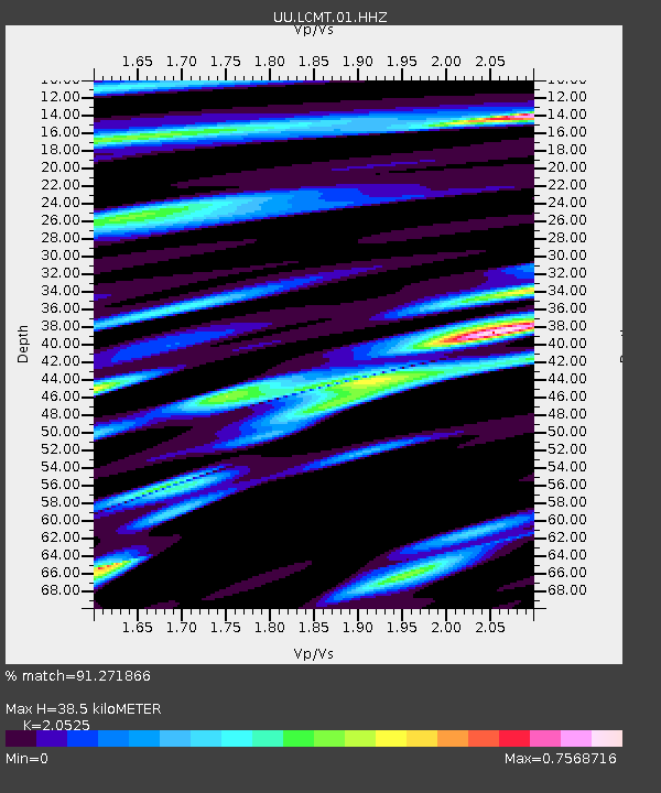
| Estimated Moho Depth: |
38.5 km |
| Estimated Crust Vp/Vs: |
2.05 |
| Assumed Crust Vp: |
6.194 km/s |
| Estimated Crust Vs: |
3.018 km/s |
| Estimated Crust Poisson's Ratio: |
0.34 |
|
| Radial Match: |
91.271866 % |
| Radial Bump: |
357 |
| Transverse Match: |
88.09975 % |
| Transverse Bump: |
400 |
| SOD ConfigId: |
1259291 |
| Insert Time: |
2015-12-08 23:48:04.354 +0000 |
| GWidth: |
2.5 |
| Max Bumps: |
400 |
| Tol: |
0.001 |
|
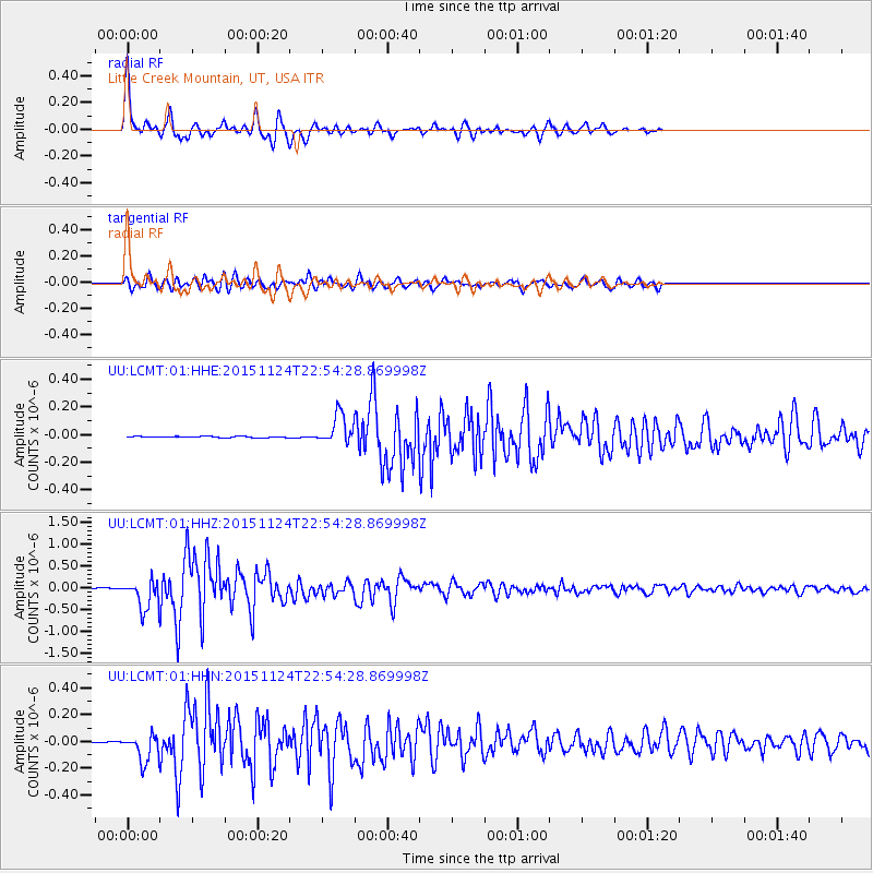
Signal To Noise
| Channel | StoN | STA | LTA |
| UU:LCMT:01:HHZ:20151124T22:54:28.869998Z | 36.66062 | 3.2335547E-7 | 8.82024E-9 |
| UU:LCMT:01:HHN:20151124T22:54:28.869998Z | 17.385445 | 1.0042116E-7 | 5.7761627E-9 |
| UU:LCMT:01:HHE:20151124T22:54:28.869998Z | 23.25145 | 1.06845775E-7 | 4.5952304E-9 |
| Arrivals |
| Ps | 6.8 SECOND |
| PpPs | 18 SECOND |
| PsPs/PpSs | 25 SECOND |


