You are here: Home > Network List > IM - International Miscellaneous Stations Stations List
> Station TX32 Lajitas Array Site 32 (same as tx01 and TX00) > Earthquake Result Viewer
TX32 Lajitas Array Site 32 (same as tx01 and TX00) - Earthquake Result Viewer
| Earthquake location: |
Peru-Ecuador Border Region |
| Earthquake latitude/longitude: |
-2.7/-75.3 |
| Earthquake time(UTC): |
2017/04/18 (108) 17:49:55 GMT |
| Earthquake Depth: |
11 km |
| Earthquake Magnitude: |
6.0 Mww |
| Earthquake Catalog/Contributor: |
NEIC PDE/us |
|
| Network: |
IM International Miscellaneous Stations |
| Station: |
TX32 Lajitas Array Site 32 (same as tx01 and TX00) |
| Lat/Lon: |
29.33 N/103.67 W |
| Elevation: |
996 m |
|
| Distance: |
41.9 deg |
| Az: |
321.59 deg |
| Baz: |
134.706 deg |
| Ray Param: |
0.07350501 |
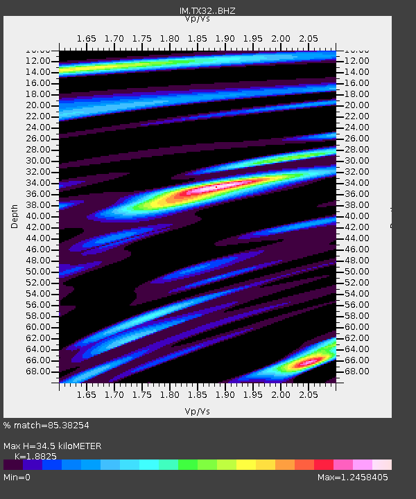
| Estimated Moho Depth: |
34.5 km |
| Estimated Crust Vp/Vs: |
1.88 |
| Assumed Crust Vp: |
6.419 km/s |
| Estimated Crust Vs: |
3.41 km/s |
| Estimated Crust Poisson's Ratio: |
0.30 |
|
| Radial Match: |
85.38254 % |
| Radial Bump: |
400 |
| Transverse Match: |
69.859116 % |
| Transverse Bump: |
400 |
| SOD ConfigId: |
11737051 |
| Insert Time: |
2019-04-27 03:38:48.960 +0000 |
| GWidth: |
2.5 |
| Max Bumps: |
400 |
| Tol: |
0.001 |
|

Signal To Noise
| Channel | StoN | STA | LTA |
| IM:TX32: :BHZ:20170418T17:57:14.57399Z | 24.03395 | 2.7564909E-6 | 1.14691545E-7 |
| IM:TX32: :BHN:20170418T17:57:14.57399Z | 9.59802 | 1.5083571E-6 | 1.5715294E-7 |
| IM:TX32: :BHE:20170418T17:57:14.57399Z | 13.370359 | 1.1073039E-6 | 8.2817806E-8 |
| Arrivals |
| Ps | 5.1 SECOND |
| PpPs | 15 SECOND |
| PsPs/PpSs | 20 SECOND |


