You are here: Home > Network List > LD - Lamont-Doherty Cooperative Seismographic Network Stations List
> Station GEDE Greenville, DE, USA > Earthquake Result Viewer
GEDE Greenville, DE, USA - Earthquake Result Viewer
*The percent match for this event was below the threshold and hence no stack was calculated.
| Earthquake location: |
Peru-Ecuador Border Region |
| Earthquake latitude/longitude: |
-2.7/-75.3 |
| Earthquake time(UTC): |
2017/04/18 (108) 17:49:55 GMT |
| Earthquake Depth: |
11 km |
| Earthquake Magnitude: |
6.0 Mww |
| Earthquake Catalog/Contributor: |
NEIC PDE/us |
|
| Network: |
LD Lamont-Doherty Cooperative Seismographic Network |
| Station: |
GEDE Greenville, DE, USA |
| Lat/Lon: |
39.81 N/75.64 W |
| Elevation: |
105 m |
|
| Distance: |
42.3 deg |
| Az: |
359.622 deg |
| Baz: |
179.509 deg |
| Ray Param: |
$rayparam |
*The percent match for this event was below the threshold and hence was not used in the summary stack. |
|
| Radial Match: |
77.08593 % |
| Radial Bump: |
253 |
| Transverse Match: |
61.397865 % |
| Transverse Bump: |
400 |
| SOD ConfigId: |
11737051 |
| Insert Time: |
2019-04-27 03:39:10.740 +0000 |
| GWidth: |
2.5 |
| Max Bumps: |
400 |
| Tol: |
0.001 |
|
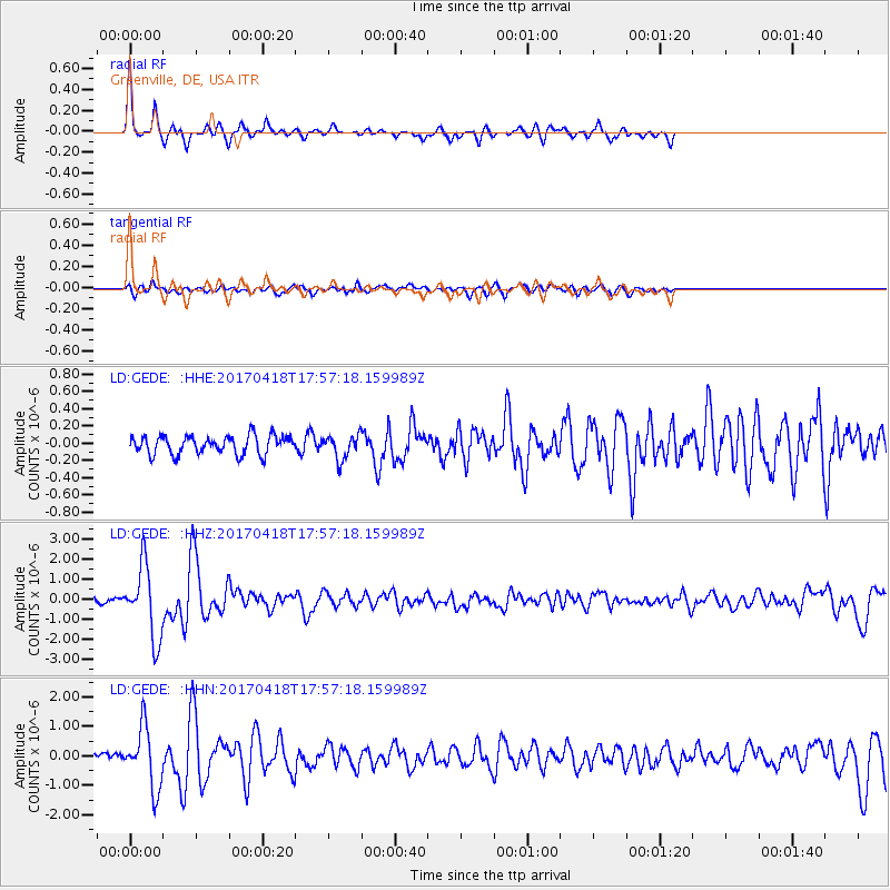
Signal To Noise
| Channel | StoN | STA | LTA |
| LD:GEDE: :HHZ:20170418T17:57:18.159989Z | 12.056548 | 1.8044033E-6 | 1.4966169E-7 |
| LD:GEDE: :HHN:20170418T17:57:18.159989Z | 9.818653 | 1.0312342E-6 | 1.0502808E-7 |
| LD:GEDE: :HHE:20170418T17:57:18.159989Z | 1.2968633 | 1.3816698E-7 | 1.0653936E-7 |
| Arrivals |
| Ps | |
| PpPs | |
| PsPs/PpSs | |


