You are here: Home > Network List > LD - Lamont-Doherty Cooperative Seismographic Network Stations List
> Station MSNJ Montclair State University, NJ > Earthquake Result Viewer
MSNJ Montclair State University, NJ - Earthquake Result Viewer
| Earthquake location: |
Peru-Ecuador Border Region |
| Earthquake latitude/longitude: |
-2.7/-75.3 |
| Earthquake time(UTC): |
2017/04/18 (108) 17:49:55 GMT |
| Earthquake Depth: |
11 km |
| Earthquake Magnitude: |
6.0 Mww |
| Earthquake Catalog/Contributor: |
NEIC PDE/us |
|
| Network: |
LD Lamont-Doherty Cooperative Seismographic Network |
| Station: |
MSNJ Montclair State University, NJ |
| Lat/Lon: |
40.88 N/74.18 W |
| Elevation: |
132 m |
|
| Distance: |
43.4 deg |
| Az: |
1.239 deg |
| Baz: |
181.633 deg |
| Ray Param: |
0.072565526 |
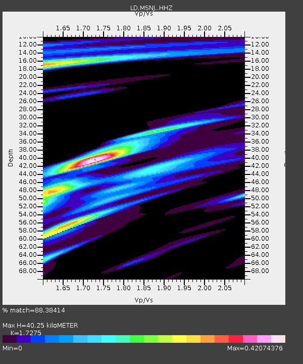
| Estimated Moho Depth: |
40.25 km |
| Estimated Crust Vp/Vs: |
1.73 |
| Assumed Crust Vp: |
6.283 km/s |
| Estimated Crust Vs: |
3.637 km/s |
| Estimated Crust Poisson's Ratio: |
0.25 |
|
| Radial Match: |
88.38414 % |
| Radial Bump: |
275 |
| Transverse Match: |
65.29156 % |
| Transverse Bump: |
400 |
| SOD ConfigId: |
11737051 |
| Insert Time: |
2019-04-27 03:39:16.070 +0000 |
| GWidth: |
2.5 |
| Max Bumps: |
400 |
| Tol: |
0.001 |
|

Signal To Noise
| Channel | StoN | STA | LTA |
| LD:MSNJ: :HHZ:20170418T17:57:26.925004Z | 9.514907 | 2.4537612E-6 | 2.57886E-7 |
| LD:MSNJ: :HHN:20170418T17:57:26.925004Z | 6.331701 | 1.4830507E-6 | 2.3422628E-7 |
| LD:MSNJ: :HHE:20170418T17:57:26.925004Z | 1.0832952 | 2.3209222E-7 | 2.1424651E-7 |
| Arrivals |
| Ps | 5.0 SECOND |
| PpPs | 16 SECOND |
| PsPs/PpSs | 21 SECOND |


