You are here: Home > Network List > N4 - Central and EAstern US Network Stations List
> Station V51A Loudon, TN, USA > Earthquake Result Viewer
V51A Loudon, TN, USA - Earthquake Result Viewer
| Earthquake location: |
Peru-Ecuador Border Region |
| Earthquake latitude/longitude: |
-2.7/-75.3 |
| Earthquake time(UTC): |
2017/04/18 (108) 17:49:55 GMT |
| Earthquake Depth: |
11 km |
| Earthquake Magnitude: |
6.0 Mww |
| Earthquake Catalog/Contributor: |
NEIC PDE/us |
|
| Network: |
N4 Central and EAstern US Network |
| Station: |
V51A Loudon, TN, USA |
| Lat/Lon: |
35.80 N/84.35 W |
| Elevation: |
243 m |
|
| Distance: |
39.3 deg |
| Az: |
348.347 deg |
| Baz: |
165.629 deg |
| Ray Param: |
0.07508907 |
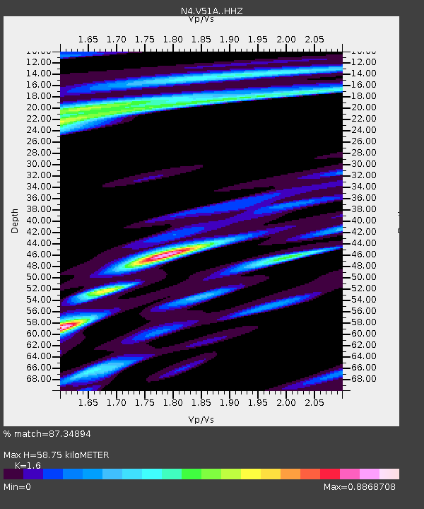
| Estimated Moho Depth: |
58.75 km |
| Estimated Crust Vp/Vs: |
1.60 |
| Assumed Crust Vp: |
6.35 km/s |
| Estimated Crust Vs: |
3.969 km/s |
| Estimated Crust Poisson's Ratio: |
0.18 |
|
| Radial Match: |
87.34894 % |
| Radial Bump: |
315 |
| Transverse Match: |
64.81703 % |
| Transverse Bump: |
400 |
| SOD ConfigId: |
11737051 |
| Insert Time: |
2019-04-27 03:41:21.216 +0000 |
| GWidth: |
2.5 |
| Max Bumps: |
400 |
| Tol: |
0.001 |
|

Signal To Noise
| Channel | StoN | STA | LTA |
| N4:V51A: :HHZ:20170418T17:56:52.800004Z | 14.345021 | 2.1946512E-6 | 1.5299044E-7 |
| N4:V51A: :HHN:20170418T17:56:52.800004Z | 8.397395 | 1.0472943E-6 | 1.2471656E-7 |
| N4:V51A: :HHE:20170418T17:56:52.800004Z | 3.3611703 | 3.121946E-7 | 9.2882715E-8 |
| Arrivals |
| Ps | 6.0 SECOND |
| PpPs | 22 SECOND |
| PsPs/PpSs | 28 SECOND |


