You are here: Home > Network List > N4 - Central and EAstern US Network Stations List
> Station X58A Rowland, NC, USA > Earthquake Result Viewer
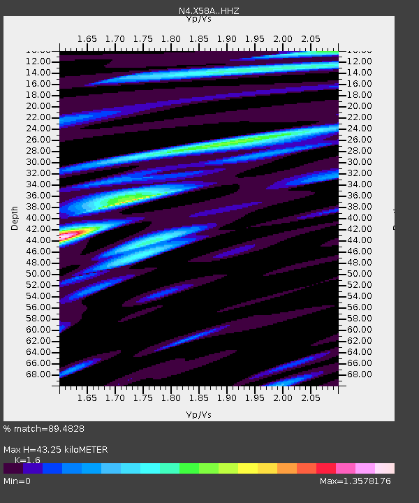
X58A Rowland, NC, USA - Earthquake Result Viewer
| Earthquake location: |
Peru-Ecuador Border Region |
| Earthquake latitude/longitude: |
-2.7/-75.3 |
| Earthquake time(UTC): |
2017/04/18 (108) 17:49:55 GMT |
| Earthquake Depth: |
11 km |
| Earthquake Magnitude: |
6.0 Mww |
| Earthquake Catalog/Contributor: |
NEIC PDE/us |
|
| Network: |
N4 Central and EAstern US Network |
| Station: |
X58A Rowland, NC, USA |
| Lat/Lon: |
34.55 N/79.34 W |
| Elevation: |
45 m |
|
| Distance: |
37.3 deg |
| Az: |
354.499 deg |
| Baz: |
173.338 deg |
| Ray Param: |
0.07622144 |
| Estimated Moho Depth: |
43.25 km |
| Estimated Crust Vp/Vs: |
1.60 |
| Assumed Crust Vp: |
6.565 km/s |
| Estimated Crust Vs: |
4.103 km/s |
| Estimated Crust Poisson's Ratio: |
0.18 |
|
| Radial Match: |
89.4828 % |
| Radial Bump: |
393 |
| Transverse Match: |
65.9801 % |
| Transverse Bump: |
400 |
| SOD ConfigId: |
11737051 |
| Insert Time: |
2019-04-27 03:41:31.135 +0000 |
| GWidth: |
2.5 |
| Max Bumps: |
400 |
| Tol: |
0.001 |
|

Signal To Noise
| Channel | StoN | STA | LTA |
| N4:X58A: :HHZ:20170418T17:56:36.180009Z | 16.889992 | 3.198599E-6 | 1.8937835E-7 |
| N4:X58A: :HHN:20170418T17:56:36.180009Z | 15.5514555 | 2.8747681E-6 | 1.8485524E-7 |
| N4:X58A: :HHE:20170418T17:56:36.180009Z | 2.3060215 | 4.8697154E-7 | 2.1117388E-7 |
| Arrivals |
| Ps | 4.3 SECOND |
| PpPs | 16 SECOND |
| PsPs/PpSs | 20 SECOND |


