You are here: Home > Network List > WY - Yellowstone Wyoming Seismic Network Stations List
> Station YMP Mirror Lake Plateau, YNP, WY, USA > Earthquake Result Viewer
YMP Mirror Lake Plateau, YNP, WY, USA - Earthquake Result Viewer
| Earthquake location: |
Peru-Brazil Border Region |
| Earthquake latitude/longitude: |
-10.6/-71.0 |
| Earthquake time(UTC): |
2015/11/24 (328) 22:45:38 GMT |
| Earthquake Depth: |
602 km |
| Earthquake Magnitude: |
7.5 MWW, 6.9 MI |
| Earthquake Catalog/Contributor: |
NEIC PDE/NEIC COMCAT |
|
| Network: |
WY Yellowstone Wyoming Seismic Network |
| Station: |
YMP Mirror Lake Plateau, YNP, WY, USA |
| Lat/Lon: |
44.74 N/110.16 W |
| Elevation: |
2774 m |
|
| Distance: |
65.5 deg |
| Az: |
330.331 deg |
| Baz: |
136.93 deg |
| Ray Param: |
0.05600396 |
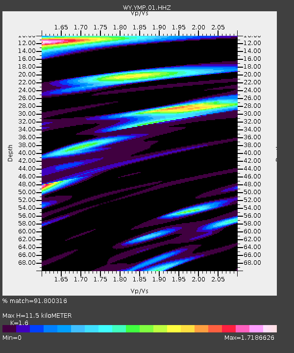
| Estimated Moho Depth: |
11.5 km |
| Estimated Crust Vp/Vs: |
1.60 |
| Assumed Crust Vp: |
6.35 km/s |
| Estimated Crust Vs: |
3.969 km/s |
| Estimated Crust Poisson's Ratio: |
0.18 |
|
| Radial Match: |
91.800316 % |
| Radial Bump: |
400 |
| Transverse Match: |
88.561386 % |
| Transverse Bump: |
400 |
| SOD ConfigId: |
1259291 |
| Insert Time: |
2015-12-08 23:50:10.989 +0000 |
| GWidth: |
2.5 |
| Max Bumps: |
400 |
| Tol: |
0.001 |
|

Signal To Noise
| Channel | StoN | STA | LTA |
| WY:YMP:01:HHZ:20151124T22:54:52.297976Z | 39.441635 | 3.789334E-7 | 9.607447E-9 |
| WY:YMP:01:HHN:20151124T22:54:52.297976Z | 11.237553 | 1.4288291E-7 | 1.27147715E-8 |
| WY:YMP:01:HHE:20151124T22:54:52.297976Z | 16.128904 | 2.1706704E-7 | 1.3458264E-8 |
| Arrivals |
| Ps | 1.1 SECOND |
| PpPs | 4.5 SECOND |
| PsPs/PpSs | 5.7 SECOND |


