You are here: Home > Network List > PE - Penn State Network Stations List
> Station PABK Blue Knob State Park, Imler, PA > Earthquake Result Viewer
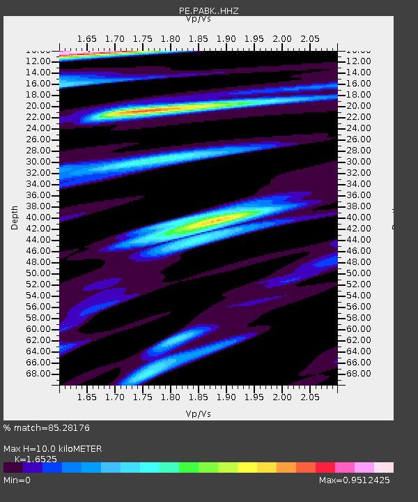
PABK Blue Knob State Park, Imler, PA - Earthquake Result Viewer
| Earthquake location: |
Peru-Ecuador Border Region |
| Earthquake latitude/longitude: |
-2.7/-75.3 |
| Earthquake time(UTC): |
2017/04/18 (108) 17:49:55 GMT |
| Earthquake Depth: |
11 km |
| Earthquake Magnitude: |
6.0 Mww |
| Earthquake Catalog/Contributor: |
NEIC PDE/us |
|
| Network: |
PE Penn State Network |
| Station: |
PABK Blue Knob State Park, Imler, PA |
| Lat/Lon: |
40.27 N/78.58 W |
| Elevation: |
482 m |
|
| Distance: |
42.9 deg |
| Az: |
356.313 deg |
| Baz: |
175.185 deg |
| Ray Param: |
0.072898775 |
| Estimated Moho Depth: |
10.0 km |
| Estimated Crust Vp/Vs: |
1.65 |
| Assumed Crust Vp: |
6.121 km/s |
| Estimated Crust Vs: |
3.704 km/s |
| Estimated Crust Poisson's Ratio: |
0.21 |
|
| Radial Match: |
85.28176 % |
| Radial Bump: |
400 |
| Transverse Match: |
73.074326 % |
| Transverse Bump: |
400 |
| SOD ConfigId: |
11737051 |
| Insert Time: |
2019-04-27 03:43:05.186 +0000 |
| GWidth: |
2.5 |
| Max Bumps: |
400 |
| Tol: |
0.001 |
|

Signal To Noise
| Channel | StoN | STA | LTA |
| PE:PABK: :HHZ:20170418T17:57:22.689988Z | 19.787113 | 1.36482095E-5 | 6.897524E-7 |
| PE:PABK: :HHN:20170418T17:57:22.689988Z | 8.448505 | 5.7425705E-6 | 6.7971433E-7 |
| PE:PABK: :HHE:20170418T17:57:22.689988Z | 2.0619674 | 8.422561E-7 | 4.0847206E-7 |
| Arrivals |
| Ps | 1.1 SECOND |
| PpPs | 4.1 SECOND |
| PsPs/PpSs | 5.2 SECOND |


