You are here: Home > Network List > ZW13 - Locating North Texas Earthquakes Stations List
> Station IFDF Dallas Firestation > Earthquake Result Viewer
IFDF Dallas Firestation - Earthquake Result Viewer
| Earthquake location: |
Peru-Brazil Border Region |
| Earthquake latitude/longitude: |
-10.6/-71.0 |
| Earthquake time(UTC): |
2015/11/24 (328) 22:45:38 GMT |
| Earthquake Depth: |
602 km |
| Earthquake Magnitude: |
7.5 MWW, 6.9 MI |
| Earthquake Catalog/Contributor: |
NEIC PDE/NEIC COMCAT |
|
| Network: |
ZW Locating North Texas Earthquakes |
| Station: |
IFDF Dallas Firestation |
| Lat/Lon: |
32.78 N/96.90 W |
| Elevation: |
130 m |
|
| Distance: |
49.7 deg |
| Az: |
331.117 deg |
| Baz: |
145.686 deg |
| Ray Param: |
0.06567413 |
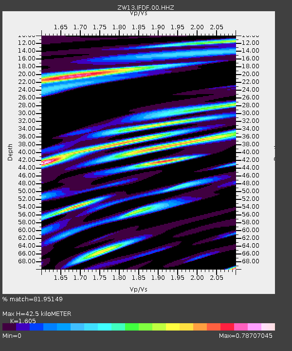
| Estimated Moho Depth: |
42.5 km |
| Estimated Crust Vp/Vs: |
1.61 |
| Assumed Crust Vp: |
6.38 km/s |
| Estimated Crust Vs: |
3.975 km/s |
| Estimated Crust Poisson's Ratio: |
0.18 |
|
| Radial Match: |
81.95149 % |
| Radial Bump: |
400 |
| Transverse Match: |
76.61824 % |
| Transverse Bump: |
400 |
| SOD ConfigId: |
1259291 |
| Insert Time: |
2015-12-08 23:50:49.934 +0000 |
| GWidth: |
2.5 |
| Max Bumps: |
400 |
| Tol: |
0.001 |
|

Signal To Noise
| Channel | StoN | STA | LTA |
| ZW:IFDF:00:HHZ:20151124T22:53:06.000002Z | 13.560218 | 5.517734E-7 | 4.0690598E-8 |
| ZW:IFDF:00:HH1:20151124T22:53:06.000002Z | 3.540555 | 2.4472675E-7 | 6.9121015E-8 |
| ZW:IFDF:00:HH2:20151124T22:53:06.000002Z | 2.5709965 | 1.4485612E-7 | 5.63424E-8 |
| Arrivals |
| Ps | 4.3 SECOND |
| PpPs | 16 SECOND |
| PsPs/PpSs | 21 SECOND |


