You are here: Home > Network List > TA - USArray Transportable Network (new EarthScope stations) Stations List
> Station D24K Happy Valley, AK, USA > Earthquake Result Viewer
D24K Happy Valley, AK, USA - Earthquake Result Viewer
| Earthquake location: |
Peru-Ecuador Border Region |
| Earthquake latitude/longitude: |
-2.7/-75.3 |
| Earthquake time(UTC): |
2017/04/18 (108) 17:49:55 GMT |
| Earthquake Depth: |
11 km |
| Earthquake Magnitude: |
6.0 Mww |
| Earthquake Catalog/Contributor: |
NEIC PDE/us |
|
| Network: |
TA USArray Transportable Network (new EarthScope stations) |
| Station: |
D24K Happy Valley, AK, USA |
| Lat/Lon: |
69.15 N/148.82 W |
| Elevation: |
292 m |
|
| Distance: |
86.7 deg |
| Az: |
339.89 deg |
| Baz: |
106.379 deg |
| Ray Param: |
0.043849446 |
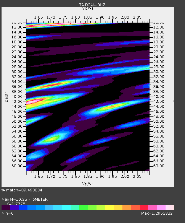
| Estimated Moho Depth: |
10.25 km |
| Estimated Crust Vp/Vs: |
1.78 |
| Assumed Crust Vp: |
6.316 km/s |
| Estimated Crust Vs: |
3.553 km/s |
| Estimated Crust Poisson's Ratio: |
0.27 |
|
| Radial Match: |
89.493034 % |
| Radial Bump: |
400 |
| Transverse Match: |
86.524216 % |
| Transverse Bump: |
400 |
| SOD ConfigId: |
11737051 |
| Insert Time: |
2019-04-27 03:44:27.754 +0000 |
| GWidth: |
2.5 |
| Max Bumps: |
400 |
| Tol: |
0.001 |
|
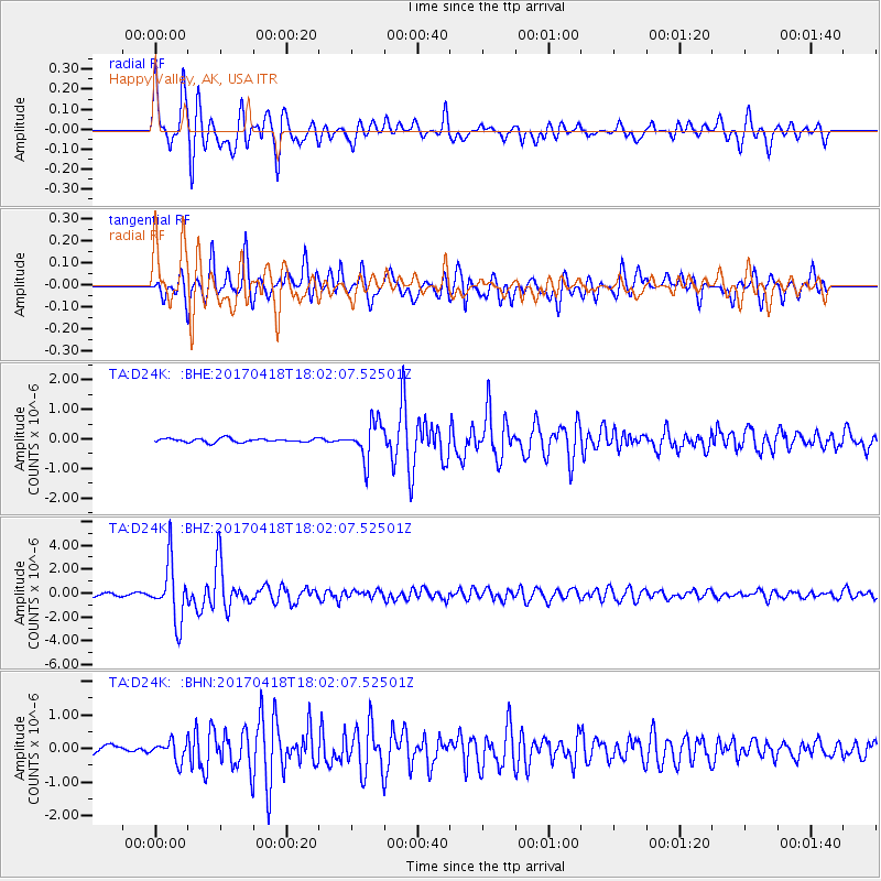
Signal To Noise
| Channel | StoN | STA | LTA |
| TA:D24K: :BHZ:20170418T18:02:07.52501Z | 20.410404 | 2.4170363E-6 | 1.1842178E-7 |
| TA:D24K: :BHN:20170418T18:02:07.52501Z | 2.2136235 | 2.8782014E-7 | 1.3002217E-7 |
| TA:D24K: :BHE:20170418T18:02:07.52501Z | 9.509643 | 6.172443E-7 | 6.4907205E-8 |
| Arrivals |
| Ps | 1.3 SECOND |
| PpPs | 4.4 SECOND |
| PsPs/PpSs | 5.7 SECOND |


