You are here: Home > Network List > TA - USArray Transportable Network (new EarthScope stations) Stations List
> Station X29A Tulia, tX, USA > Earthquake Result Viewer
X29A Tulia, tX, USA - Earthquake Result Viewer
| Earthquake location: |
Tonga Islands |
| Earthquake latitude/longitude: |
-20.8/-174.3 |
| Earthquake time(UTC): |
2009/07/30 (211) 20:05:34 GMT |
| Earthquake Depth: |
10 km |
| Earthquake Magnitude: |
5.9 MB, 5.7 MS, 5.8 MW, 5.7 MW |
| Earthquake Catalog/Contributor: |
WHDF/NEIC |
|
| Network: |
TA USArray Transportable Network (new EarthScope stations) |
| Station: |
X29A Tulia, tX, USA |
| Lat/Lon: |
34.45 N/101.70 W |
| Elevation: |
1039 m |
|
| Distance: |
88.1 deg |
| Az: |
52.076 deg |
| Baz: |
243.222 deg |
| Ray Param: |
0.042812582 |
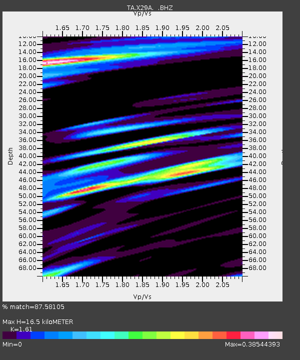
| Estimated Moho Depth: |
16.5 km |
| Estimated Crust Vp/Vs: |
1.61 |
| Assumed Crust Vp: |
6.426 km/s |
| Estimated Crust Vs: |
3.991 km/s |
| Estimated Crust Poisson's Ratio: |
0.19 |
|
| Radial Match: |
87.58105 % |
| Radial Bump: |
400 |
| Transverse Match: |
65.28853 % |
| Transverse Bump: |
400 |
| SOD ConfigId: |
2622 |
| Insert Time: |
2010-03-05 23:10:54.833 +0000 |
| GWidth: |
2.5 |
| Max Bumps: |
400 |
| Tol: |
0.001 |
|

Signal To Noise
| Channel | StoN | STA | LTA |
| TA:X29A: :BHZ:20090730T20:17:54.273997Z | 3.9952931 | 6.0247424E-7 | 1.5079601E-7 |
| TA:X29A: :BHN:20090730T20:17:54.273997Z | 1.0113666 | 1.8015118E-7 | 1.7812648E-7 |
| TA:X29A: :BHE:20090730T20:17:54.273997Z | 1.206053 | 2.0766497E-7 | 1.721856E-7 |
| Arrivals |
| Ps | 1.6 SECOND |
| PpPs | 6.5 SECOND |
| PsPs/PpSs | 8.1 SECOND |


