You are here: Home > Network List > TA - USArray Transportable Network (new EarthScope stations) Stations List
> Station G23K Bananza Creek, AK, USA > Earthquake Result Viewer
G23K Bananza Creek, AK, USA - Earthquake Result Viewer

| Earthquake location: |
Peru-Ecuador Border Region |
| Earthquake latitude/longitude: |
-2.7/-75.3 |
| Earthquake time(UTC): |
2017/04/18 (108) 17:49:55 GMT |
| Earthquake Depth: |
11 km |
| Earthquake Magnitude: |
6.0 Mww |
| Earthquake Catalog/Contributor: |
NEIC PDE/us |
|
| Network: |
TA USArray Transportable Network (new EarthScope stations) |
| Station: |
G23K Bananza Creek, AK, USA |
| Lat/Lon: |
66.71 N/150.02 W |
| Elevation: |
746 m |
|
| Distance: |
86.5 deg |
| Az: |
337.401 deg |
| Baz: |
105.12 deg |
| Ray Param: |
0.044017605 |
| Estimated Moho Depth: |
21.75 km |
| Estimated Crust Vp/Vs: |
1.60 |
| Assumed Crust Vp: |
6.577 km/s |
| Estimated Crust Vs: |
4.11 km/s |
| Estimated Crust Poisson's Ratio: |
0.18 |
|
| Radial Match: |
94.50416 % |
| Radial Bump: |
400 |
| Transverse Match: |
89.25148 % |
| Transverse Bump: |
400 |
| SOD ConfigId: |
11737051 |
| Insert Time: |
2019-04-27 03:44:40.142 +0000 |
| GWidth: |
2.5 |
| Max Bumps: |
400 |
| Tol: |
0.001 |
|
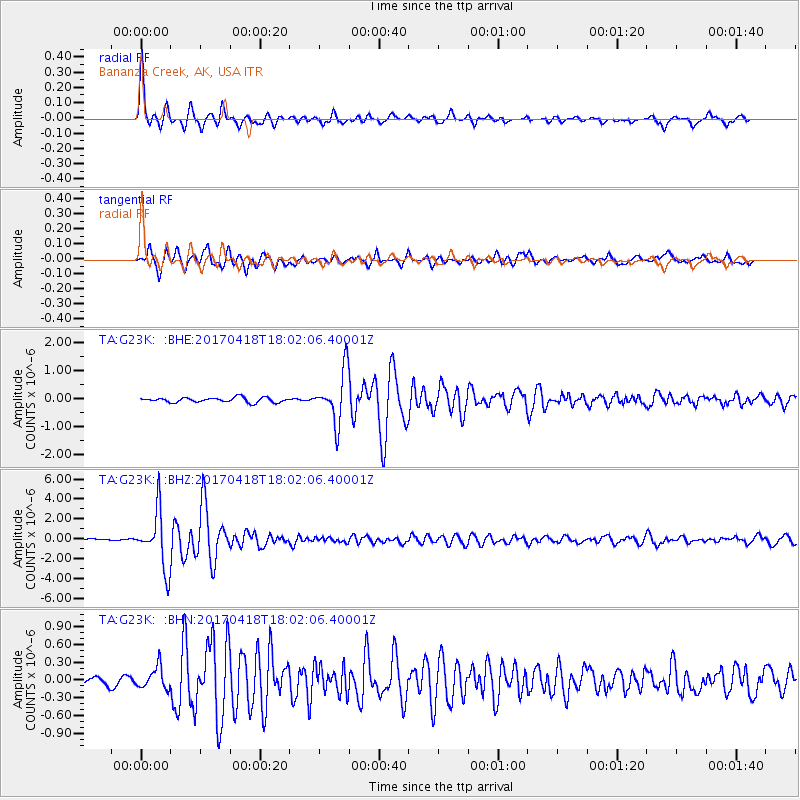
Signal To Noise
| Channel | StoN | STA | LTA |
| TA:G23K: :BHZ:20170418T18:02:06.40001Z | 32.27085 | 2.825814E-6 | 8.7565525E-8 |
| TA:G23K: :BHN:20170418T18:02:06.40001Z | 1.7448221 | 1.8294124E-7 | 1.0484806E-7 |
| TA:G23K: :BHE:20170418T18:02:06.40001Z | 10.486956 | 9.031218E-7 | 8.611859E-8 |
| Arrivals |
| Ps | 2.0 SECOND |
| PpPs | 8.4 SECOND |
| PsPs/PpSs | 10 SECOND |


