You are here: Home > Network List > TA - USArray Transportable Network (new EarthScope stations) Stations List
> Station X29A Tulia, tX, USA > Earthquake Result Viewer
X29A Tulia, tX, USA - Earthquake Result Viewer
| Earthquake location: |
Southeast Of Honshu, Japan |
| Earthquake latitude/longitude: |
32.8/140.4 |
| Earthquake time(UTC): |
2009/08/12 (224) 22:48:51 GMT |
| Earthquake Depth: |
53 km |
| Earthquake Magnitude: |
6.2 MB, 6.6 MW, 6.6 MW |
| Earthquake Catalog/Contributor: |
WHDF/NEIC |
|
| Network: |
TA USArray Transportable Network (new EarthScope stations) |
| Station: |
X29A Tulia, tX, USA |
| Lat/Lon: |
34.45 N/101.70 W |
| Elevation: |
1039 m |
|
| Distance: |
91.3 deg |
| Az: |
46.93 deg |
| Baz: |
311.901 deg |
| Ray Param: |
0.041606463 |
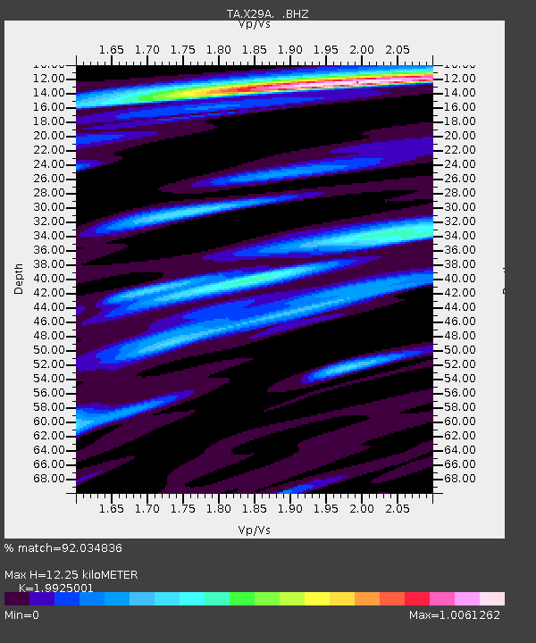
| Estimated Moho Depth: |
12.25 km |
| Estimated Crust Vp/Vs: |
1.99 |
| Assumed Crust Vp: |
6.426 km/s |
| Estimated Crust Vs: |
3.225 km/s |
| Estimated Crust Poisson's Ratio: |
0.33 |
|
| Radial Match: |
92.034836 % |
| Radial Bump: |
400 |
| Transverse Match: |
81.96223 % |
| Transverse Bump: |
400 |
| SOD ConfigId: |
2622 |
| Insert Time: |
2010-03-05 23:10:57.657 +0000 |
| GWidth: |
2.5 |
| Max Bumps: |
400 |
| Tol: |
0.001 |
|
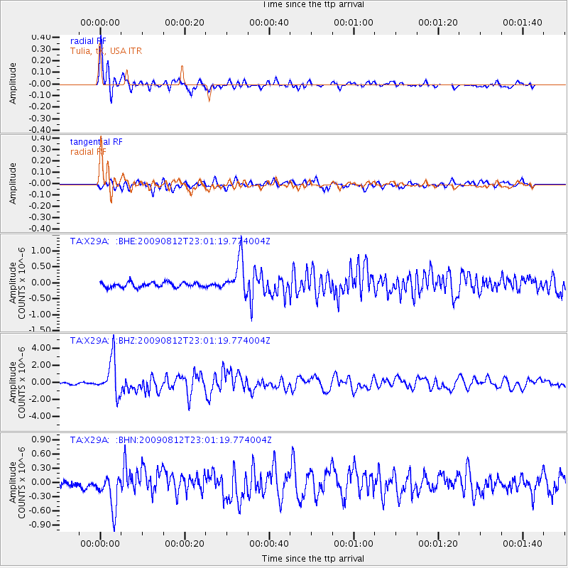
Signal To Noise
| Channel | StoN | STA | LTA |
| TA:X29A: :BHZ:20090812T23:01:19.774004Z | 31.950722 | 2.1712815E-6 | 6.79572E-8 |
| TA:X29A: :BHN:20090812T23:01:19.774004Z | 4.137093 | 3.6827157E-7 | 8.901699E-8 |
| TA:X29A: :BHE:20090812T23:01:19.774004Z | 7.4094105 | 5.7097833E-7 | 7.706124E-8 |
| Arrivals |
| Ps | 1.9 SECOND |
| PpPs | 5.6 SECOND |
| PsPs/PpSs | 7.5 SECOND |


