You are here: Home > Network List > TA - USArray Transportable Network (new EarthScope stations) Stations List
> Station KMSC Kings Mountain, Blacksburg, SC, USA > Earthquake Result Viewer
KMSC Kings Mountain, Blacksburg, SC, USA - Earthquake Result Viewer
| Earthquake location: |
Peru-Ecuador Border Region |
| Earthquake latitude/longitude: |
-2.7/-75.3 |
| Earthquake time(UTC): |
2017/04/18 (108) 17:49:55 GMT |
| Earthquake Depth: |
11 km |
| Earthquake Magnitude: |
6.0 Mww |
| Earthquake Catalog/Contributor: |
NEIC PDE/us |
|
| Network: |
TA USArray Transportable Network (new EarthScope stations) |
| Station: |
KMSC Kings Mountain, Blacksburg, SC, USA |
| Lat/Lon: |
35.14 N/81.33 W |
| Elevation: |
240 m |
|
| Distance: |
38.1 deg |
| Az: |
351.98 deg |
| Baz: |
170.21 deg |
| Ray Param: |
0.075759694 |
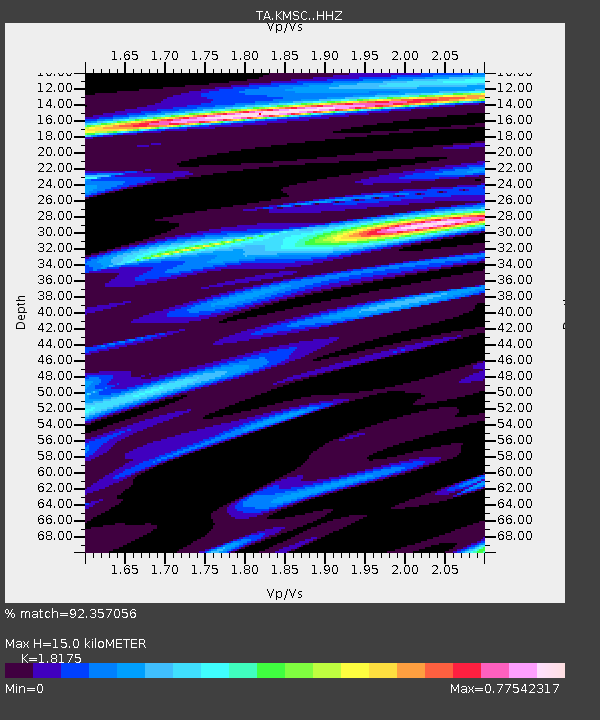
| Estimated Moho Depth: |
15.0 km |
| Estimated Crust Vp/Vs: |
1.82 |
| Assumed Crust Vp: |
6.419 km/s |
| Estimated Crust Vs: |
3.532 km/s |
| Estimated Crust Poisson's Ratio: |
0.28 |
|
| Radial Match: |
92.357056 % |
| Radial Bump: |
245 |
| Transverse Match: |
69.14222 % |
| Transverse Bump: |
400 |
| SOD ConfigId: |
11737051 |
| Insert Time: |
2019-04-27 03:45:00.232 +0000 |
| GWidth: |
2.5 |
| Max Bumps: |
400 |
| Tol: |
0.001 |
|

Signal To Noise
| Channel | StoN | STA | LTA |
| TA:KMSC: :HHZ:20170418T17:56:43.060013Z | 22.550016 | 2.734222E-6 | 1.2125145E-7 |
| TA:KMSC: :HHN:20170418T17:56:43.060013Z | 18.787294 | 1.8401312E-6 | 9.794552E-8 |
| TA:KMSC: :HHE:20170418T17:56:43.060013Z | 3.742234 | 4.4509804E-7 | 1.1893912E-7 |
| Arrivals |
| Ps | 2.1 SECOND |
| PpPs | 6.1 SECOND |
| PsPs/PpSs | 8.2 SECOND |


