You are here: Home > Network List > TA - USArray Transportable Network (new EarthScope stations) Stations List
> Station L44A Lake County Forest Preserve, Grayslake, IL, USA > Earthquake Result Viewer
L44A Lake County Forest Preserve, Grayslake, IL, USA - Earthquake Result Viewer
| Earthquake location: |
Peru-Ecuador Border Region |
| Earthquake latitude/longitude: |
-2.7/-75.3 |
| Earthquake time(UTC): |
2017/04/18 (108) 17:49:55 GMT |
| Earthquake Depth: |
11 km |
| Earthquake Magnitude: |
6.0 Mww |
| Earthquake Catalog/Contributor: |
NEIC PDE/us |
|
| Network: |
TA USArray Transportable Network (new EarthScope stations) |
| Station: |
L44A Lake County Forest Preserve, Grayslake, IL, USA |
| Lat/Lon: |
42.18 N/87.91 W |
| Elevation: |
202 m |
|
| Distance: |
46.1 deg |
| Az: |
346.996 deg |
| Baz: |
162.399 deg |
| Ray Param: |
0.07082974 |
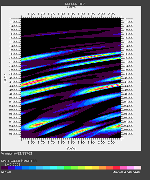
| Estimated Moho Depth: |
43.0 km |
| Estimated Crust Vp/Vs: |
2.09 |
| Assumed Crust Vp: |
6.483 km/s |
| Estimated Crust Vs: |
3.098 km/s |
| Estimated Crust Poisson's Ratio: |
0.35 |
|
| Radial Match: |
82.33762 % |
| Radial Bump: |
350 |
| Transverse Match: |
55.782898 % |
| Transverse Bump: |
400 |
| SOD ConfigId: |
11737051 |
| Insert Time: |
2019-04-27 03:45:05.456 +0000 |
| GWidth: |
2.5 |
| Max Bumps: |
400 |
| Tol: |
0.001 |
|
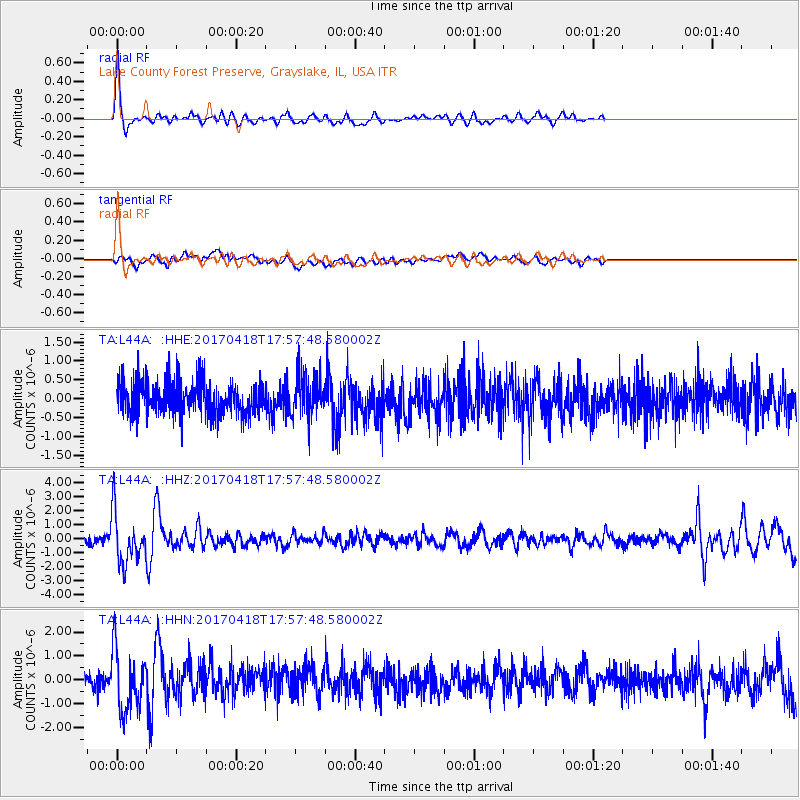
Signal To Noise
| Channel | StoN | STA | LTA |
| TA:L44A: :HHZ:20170418T17:57:48.580002Z | 5.6036267 | 1.7905566E-6 | 3.1953533E-7 |
| TA:L44A: :HHN:20170418T17:57:48.580002Z | 2.8732698 | 1.2697132E-6 | 4.4190534E-7 |
| TA:L44A: :HHE:20170418T17:57:48.580002Z | 1.2454743 | 5.529647E-7 | 4.439792E-7 |
| Arrivals |
| Ps | 7.6 SECOND |
| PpPs | 19 SECOND |
| PsPs/PpSs | 27 SECOND |


