You are here: Home > Network List > TA - USArray Transportable Network (new EarthScope stations) Stations List
> Station O30N Mendenhall, YT, Canada > Earthquake Result Viewer
O30N Mendenhall, YT, Canada - Earthquake Result Viewer
| Earthquake location: |
Peru-Ecuador Border Region |
| Earthquake latitude/longitude: |
-2.7/-75.3 |
| Earthquake time(UTC): |
2017/04/18 (108) 17:49:55 GMT |
| Earthquake Depth: |
11 km |
| Earthquake Magnitude: |
6.0 Mww |
| Earthquake Catalog/Contributor: |
NEIC PDE/us |
|
| Network: |
TA USArray Transportable Network (new EarthScope stations) |
| Station: |
O30N Mendenhall, YT, Canada |
| Lat/Lon: |
60.77 N/136.09 W |
| Elevation: |
821 m |
|
| Distance: |
78.6 deg |
| Az: |
334.085 deg |
| Baz: |
117.195 deg |
| Ray Param: |
0.049547873 |
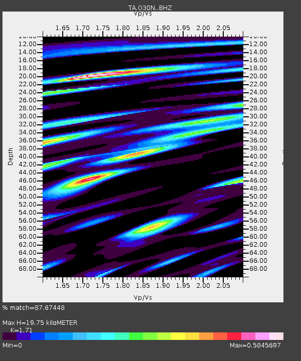
| Estimated Moho Depth: |
19.75 km |
| Estimated Crust Vp/Vs: |
1.71 |
| Assumed Crust Vp: |
6.566 km/s |
| Estimated Crust Vs: |
3.84 km/s |
| Estimated Crust Poisson's Ratio: |
0.24 |
|
| Radial Match: |
87.67448 % |
| Radial Bump: |
400 |
| Transverse Match: |
84.62767 % |
| Transverse Bump: |
400 |
| SOD ConfigId: |
11737051 |
| Insert Time: |
2019-04-27 03:45:31.461 +0000 |
| GWidth: |
2.5 |
| Max Bumps: |
400 |
| Tol: |
0.001 |
|

Signal To Noise
| Channel | StoN | STA | LTA |
| TA:O30N: :BHZ:20170418T18:01:25.324998Z | 14.738237 | 2.0417308E-6 | 1.385329E-7 |
| TA:O30N: :BHN:20170418T18:01:25.324998Z | 2.8520083 | 3.3247977E-7 | 1.1657741E-7 |
| TA:O30N: :BHE:20170418T18:01:25.324998Z | 10.1703825 | 8.436717E-7 | 8.295378E-8 |
| Arrivals |
| Ps | 2.2 SECOND |
| PpPs | 7.9 SECOND |
| PsPs/PpSs | 10 SECOND |


