You are here: Home > Network List > TA - USArray Transportable Network (new EarthScope stations) Stations List
> Station T35M Bob Quinn, BC, CAN > Earthquake Result Viewer
T35M Bob Quinn, BC, CAN - Earthquake Result Viewer
| Earthquake location: |
Peru-Ecuador Border Region |
| Earthquake latitude/longitude: |
-2.7/-75.3 |
| Earthquake time(UTC): |
2017/04/18 (108) 17:49:55 GMT |
| Earthquake Depth: |
11 km |
| Earthquake Magnitude: |
6.0 Mww |
| Earthquake Catalog/Contributor: |
NEIC PDE/us |
|
| Network: |
TA USArray Transportable Network (new EarthScope stations) |
| Station: |
T35M Bob Quinn, BC, CAN |
| Lat/Lon: |
56.98 N/130.25 W |
| Elevation: |
609 m |
|
| Distance: |
74.1 deg |
| Az: |
332.219 deg |
| Baz: |
121.749 deg |
| Ray Param: |
0.05258346 |
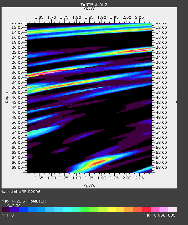
| Estimated Moho Depth: |
20.5 km |
| Estimated Crust Vp/Vs: |
2.09 |
| Assumed Crust Vp: |
6.597 km/s |
| Estimated Crust Vs: |
3.157 km/s |
| Estimated Crust Poisson's Ratio: |
0.35 |
|
| Radial Match: |
85.02096 % |
| Radial Bump: |
400 |
| Transverse Match: |
88.219864 % |
| Transverse Bump: |
400 |
| SOD ConfigId: |
11737051 |
| Insert Time: |
2019-04-27 03:45:59.880 +0000 |
| GWidth: |
2.5 |
| Max Bumps: |
400 |
| Tol: |
0.001 |
|
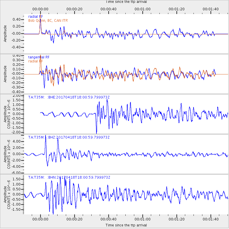
Signal To Noise
| Channel | StoN | STA | LTA |
| TA:T35M: :BHZ:20170418T18:00:59.799973Z | 11.483739 | 2.0829602E-6 | 1.8138347E-7 |
| TA:T35M: :BHN:20170418T18:00:59.799973Z | 2.6741705 | 3.6761682E-7 | 1.3746948E-7 |
| TA:T35M: :BHE:20170418T18:00:59.799973Z | 4.430105 | 6.9891445E-7 | 1.5776476E-7 |
| Arrivals |
| Ps | 3.5 SECOND |
| PpPs | 9.3 SECOND |
| PsPs/PpSs | 13 SECOND |


