You are here: Home > Network List > TA - USArray Transportable Network (new EarthScope stations) Stations List
> Station TPFO Pinon Flats, CA, USA > Earthquake Result Viewer
TPFO Pinon Flats, CA, USA - Earthquake Result Viewer
| Earthquake location: |
Peru-Ecuador Border Region |
| Earthquake latitude/longitude: |
-2.7/-75.3 |
| Earthquake time(UTC): |
2017/04/18 (108) 17:49:55 GMT |
| Earthquake Depth: |
11 km |
| Earthquake Magnitude: |
6.0 Mww |
| Earthquake Catalog/Contributor: |
NEIC PDE/us |
|
| Network: |
TA USArray Transportable Network (new EarthScope stations) |
| Station: |
TPFO Pinon Flats, CA, USA |
| Lat/Lon: |
33.61 N/116.45 W |
| Elevation: |
1275 m |
|
| Distance: |
53.0 deg |
| Az: |
316.563 deg |
| Baz: |
124.622 deg |
| Ray Param: |
0.066385895 |
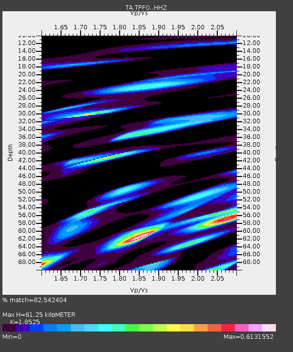
| Estimated Moho Depth: |
61.25 km |
| Estimated Crust Vp/Vs: |
1.85 |
| Assumed Crust Vp: |
6.264 km/s |
| Estimated Crust Vs: |
3.381 km/s |
| Estimated Crust Poisson's Ratio: |
0.29 |
|
| Radial Match: |
82.542404 % |
| Radial Bump: |
400 |
| Transverse Match: |
75.534775 % |
| Transverse Bump: |
400 |
| SOD ConfigId: |
11737051 |
| Insert Time: |
2019-04-27 03:46:02.163 +0000 |
| GWidth: |
2.5 |
| Max Bumps: |
400 |
| Tol: |
0.001 |
|

Signal To Noise
| Channel | StoN | STA | LTA |
| TA:TPFO: :HHZ:20170418T17:58:40.939988Z | 4.6182737 | 1.6232585E-6 | 3.51486E-7 |
| TA:TPFO: :HHN:20170418T17:58:40.939988Z | 2.9023042 | 7.169139E-7 | 2.4701544E-7 |
| TA:TPFO: :HHE:20170418T17:58:40.939988Z | 3.9363742 | 8.164867E-7 | 2.0742101E-7 |
| Arrivals |
| Ps | 8.8 SECOND |
| PpPs | 27 SECOND |
| PsPs/PpSs | 35 SECOND |


