You are here: Home > Network List > TX - Texas Seismological Network Stations List
> Station FW01 Dallas Executive Airport > Earthquake Result Viewer
FW01 Dallas Executive Airport - Earthquake Result Viewer
| Earthquake location: |
Peru-Ecuador Border Region |
| Earthquake latitude/longitude: |
-2.7/-75.3 |
| Earthquake time(UTC): |
2017/04/18 (108) 17:49:55 GMT |
| Earthquake Depth: |
11 km |
| Earthquake Magnitude: |
6.0 Mww |
| Earthquake Catalog/Contributor: |
NEIC PDE/us |
|
| Network: |
TX Texas Seismological Network |
| Station: |
FW01 Dallas Executive Airport |
| Lat/Lon: |
32.68 N/96.88 W |
| Elevation: |
203 m |
|
| Distance: |
40.7 deg |
| Az: |
331.618 deg |
| Baz: |
145.733 deg |
| Ray Param: |
0.07423603 |
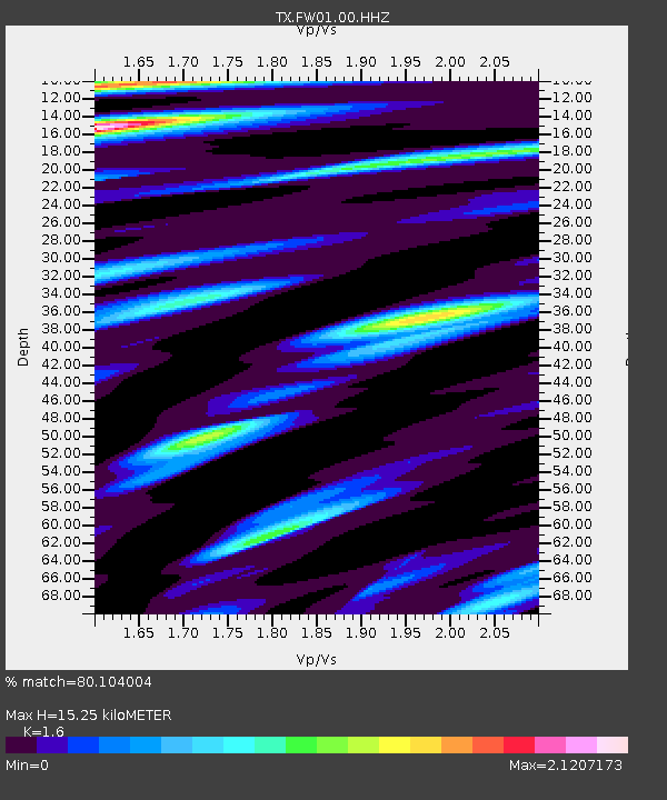
| Estimated Moho Depth: |
15.25 km |
| Estimated Crust Vp/Vs: |
1.60 |
| Assumed Crust Vp: |
6.38 km/s |
| Estimated Crust Vs: |
3.988 km/s |
| Estimated Crust Poisson's Ratio: |
0.18 |
|
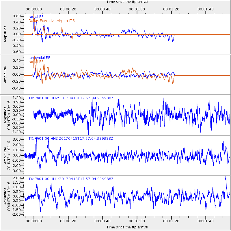
| Radial Match: |
80.104004 % |
| Radial Bump: |
400 |
| Transverse Match: |
57.592003 % |
| Transverse Bump: |
400 |
| SOD ConfigId: |
11737051 |
| Insert Time: |
2019-04-27 03:46:15.047 +0000 |
| GWidth: |
2.5 |
| Max Bumps: |
400 |
| Tol: |
0.001 |
|
Signal To Noise
| Channel | StoN | STA | LTA |
| TX:FW01:00:HHZ:20170418T17:57:04.939988Z | 4.933048 | 1.4255005E-6 | 2.8896952E-7 |
| TX:FW01:00:HH1:20170418T17:57:04.939988Z | 3.0145934 | 6.892204E-7 | 2.2862798E-7 |
| TX:FW01:00:HH2:20170418T17:57:04.939988Z | 2.3312972 | 5.152693E-7 | 2.2102256E-7 |
| Arrivals |
| Ps | 1.5 SECOND |
| PpPs | 5.8 SECOND |
| PsPs/PpSs | 7.3 SECOND |


