You are here: Home > Network List > TX - Texas Seismological Network Stations List
> Station FW02 City of Haslet > Earthquake Result Viewer
FW02 City of Haslet - Earthquake Result Viewer
| Earthquake location: |
Peru-Ecuador Border Region |
| Earthquake latitude/longitude: |
-2.7/-75.3 |
| Earthquake time(UTC): |
2017/04/18 (108) 17:49:55 GMT |
| Earthquake Depth: |
11 km |
| Earthquake Magnitude: |
6.0 Mww |
| Earthquake Catalog/Contributor: |
NEIC PDE/us |
|
| Network: |
TX Texas Seismological Network |
| Station: |
FW02 City of Haslet |
| Lat/Lon: |
32.95 N/97.34 W |
| Elevation: |
226 m |
|
| Distance: |
41.2 deg |
| Az: |
331.355 deg |
| Baz: |
145.285 deg |
| Ray Param: |
0.07396719 |
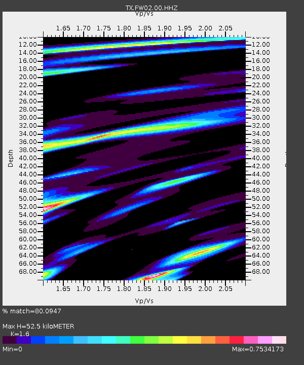
| Estimated Moho Depth: |
52.5 km |
| Estimated Crust Vp/Vs: |
1.60 |
| Assumed Crust Vp: |
6.38 km/s |
| Estimated Crust Vs: |
3.988 km/s |
| Estimated Crust Poisson's Ratio: |
0.18 |
|
| Radial Match: |
80.0947 % |
| Radial Bump: |
400 |
| Transverse Match: |
63.675476 % |
| Transverse Bump: |
400 |
| SOD ConfigId: |
11737051 |
| Insert Time: |
2019-04-27 03:46:15.235 +0000 |
| GWidth: |
2.5 |
| Max Bumps: |
400 |
| Tol: |
0.001 |
|

Signal To Noise
| Channel | StoN | STA | LTA |
| TX:FW02:00:HHZ:20170418T17:57:08.560013Z | 6.7228255 | 1.4815171E-6 | 2.2037119E-7 |
| TX:FW02:00:HH1:20170418T17:57:08.560013Z | 4.303734 | 8.909118E-7 | 2.0700902E-7 |
| TX:FW02:00:HH2:20170418T17:57:08.560013Z | 2.484581 | 6.3850473E-7 | 2.5698688E-7 |
| Arrivals |
| Ps | 5.3 SECOND |
| PpPs | 20 SECOND |
| PsPs/PpSs | 25 SECOND |


